IMAGES TAKEN NEAR TO
Timsbury Road, BATH, BA2 0AB
Introduction
This page details the photographs taken nearby to Timsbury Road, BA2 0AB by members of the Geograph project.
The Geograph project started in 2005 with the aim of publishing, organising and preserving representative images for every square kilometre of Great Britain, Ireland and the Isle of Man.

There are currently over 7.5m images from over14,400 individuals and you can help contribute to the project by visiting https://www.geograph.org.uk
Image Map
Images are licensed for reuse under creativecommons.org/licenses/by-sa/2.0
Notes
- Clicking on the map will re-center to the selected point.
- The higher the marker number, the further away the image location is from the centre of the postcode.
Image Listing (22 Images Found)
Images are licensed for reuse under creativecommons.org/licenses/by-sa/2.0
Image
Details
Distance
1
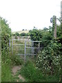
The path to Priest Barrow hill
This footpath is a well-signed route and gate off Timsbury Road. However, maps appear to show the path several metres to the south. That may be because the path is an old route that would go through the later Tilley Farm - a farm that did not arrive until the post-war period. Perhaps the path was re-routed after the farm sprang up.
Image: © Neil Owen
Taken: 17 Jun 2020
0.10 miles
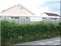
2

Farmborough welcomes careful drivers
Farmborough welcomes shoppers more.
Image: © Neil Owen
Taken: 17 Jun 2020
0.10 miles
3
Village hall and community shop
Farmborough is well served for its civic and retail facilities. The village lost its last shop in 2010, but a concerted effort to retain some form of outlet was gathered. After some six years of fund-raising a community shop was built behind the hall and opened on 30th June, 2018. Adults can become members by investing cash into the venture and have a say in its operations. The important point is that it is staffed by volunteers and benefits from lower running costs.
Image: © Neil Owen
Taken: 17 Jun 2020
0.12 miles
4
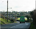
2009 : Timsbury Road, Farmborough
About to leave the village and head south for Bloomfield and Timsbury.
Image: © Maurice Pullin
Taken: 13 Feb 2009
0.12 miles
5
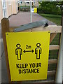
Keep your distance
The Covid-19 regulations appear almost everywhere now.
Image: © Neil Owen
Taken: 17 Jun 2020
0.12 miles
6
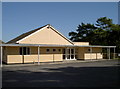
Farmborough village hall
Built in 1965, the hall provides the villagers with a central meeting point. A plaque on the wall proclaims the village as winner of the Avon Best Kept Village in 1987. Another stone plaque records the hall as being a memorial to the villagers who served and fell in the world wars, and is dated 12th March, 1966.
Image: © Neil Owen
Taken: 5 Oct 2016
0.13 miles
7
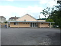
Farmborough village hall
The hall, built in 1965, on Little Lane. See Image] for a similar view of 2016. Little change on Little Lane.
Image: © Neil Owen
Taken: 17 Jun 2020
0.13 miles
8
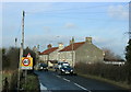
2009 : Entering Farmborough
On Timsbury Road. Somewhere along here Timsbury Road becomes Bloomfield Road but it still goes to the same place.
They might well put an exclamation mark above the 40 mph sign, even on a fine day it seems a bit quick for this road.
Image: © Maurice Pullin
Taken: 13 Feb 2009
0.17 miles
9

The Butcher's Arms
A hot spot of the village but currently closed under lockdown. It appears that the pub's landlord had actually stepped down in January anyway.
Image: © Neil Owen
Taken: 17 Jun 2020
0.19 miles
10

2009 : Butchers Arms, Farmborough
On Timsbury Road.
Image: © Maurice Pullin
Taken: 13 Feb 2009
0.19 miles