IMAGES TAKEN NEAR TO
Canton Place, BATH, BA1 6AA

Introduction

This page details the photographs taken nearby to Canton Place, BA1 6AA by members of the Geograph project.

The Geograph project started in 2005 with the aim of publishing, organising and preserving representative images for every square kilometre of Great Britain, Ireland and the Isle of Man.

There are currently over 7.5m images from over14,400 individuals and you can help contribute to the project by visiting https://www.geograph.org.uk

Image Map


Images are licensed for reuse under creativecommons.org/licenses/by-sa/2.0
Notes
  • Clicking on the map will re-center to the selected point.
  • The higher the marker number, the further away the image location is from the centre of the postcode.

Image Listing (309 Images Found)

Images are licensed for reuse under creativecommons.org/licenses/by-sa/2.0
  • ...
Image
Details
Distance
1
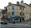
The King William, Bath
Pub and Dining Rooms at 36 Thomas Street, on the corner of the A4 London Road.
Image: © Jaggery Taken: 24 Sep 2011
0.02 miles
2
'Ablis'
This imposing visage stands atop of an old building on the London Road. See Image] for a wider view and some information about the premises.
Image: © Neil Owen Taken: 7 Jan 2014
0.03 miles
3
Looking down on the passers-by
This small but classically styled building is now home to a family firm of funeral director; they have been in business for nearly a century. However, they occupy what was once an ear and eye infirmary, which may explain the darkened bust looking down. See Image] for a better look at this 1837 work.
Image: © Neil Owen Taken: 7 Jan 2014
0.03 miles
4
Mark among the railings
A cutmark, as listed in the Benchmark Database: http://www.bench-marks.org.uk/bm53939 , on the supporting wall of the railings in Pera Road. See Image] for a wider view.
Image: © Neil Owen Taken: 7 Jan 2014
0.03 miles
5
Pera Road
At the junction with Thomas Road; the railings are home to a benchmark (see Image]).
Image: © Neil Owen Taken: 7 Jan 2014
0.03 miles
6
3-6 Cleveland Place East, Bath
Part of a set-piece approach to Cleveland Bridge (Image]), and Bathwick beyond, by Henry Goodridge, c1827-30. Curved section flanked by projecting square bays with tripartite windows. Grade II listed.
Image: © Stephen Richards Taken: 25 May 2012
0.03 miles
7
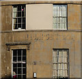
Ghost sign, Cleveland Place East, Bath
Virtually indecipherable. There is writing above both sets of windows. In the lower section is something which looks like "HEUMOGEN Ltd". On this building Image
Image: © Stephen Richards Taken: 25 May 2012
0.03 miles
8
Anglo Terrace
Anglo Terrace, Bath
Image: © Graeme Smith Taken: 25 Sep 2010
0.03 miles
9
Terraces, A4
On the right is Anglo Terrace. The flight of steps climbs to the listed Walcot Parade https://historicengland.org.uk/listing/the-list/list-entry/1395536 . "Terrace was built as St Swithin's Terrace and Butler's Buildings: its tall fronts and elevated position took advantage of the uninterrupted views over the river towards the undeveloped slopes of Bathwick". The high pavement in front of it is also listed https://historicengland.org.uk/listing/the-list/list-entry/1395537 .
Image: © Derek Harper Taken: 8 Dec 2019
0.03 miles
10
Derelict and empty premises, London Road, Bath
A few letters have fallen off the nameboard on the boarded-up shop on the right, but most remain to show that this was formerly Longacre Secondhand Furniture Bought & Sold. The blue-fronted premises at centre left are empty.
Image: © Jaggery Taken: 24 Sep 2011
0.03 miles
  • ...