IMAGES TAKEN NEAR TO
Alpine Gardens, BATH, BA1 5PE
Introduction
This page details the photographs taken nearby to Alpine Gardens, BA1 5PE by members of the Geograph project.
The Geograph project started in 2005 with the aim of publishing, organising and preserving representative images for every square kilometre of Great Britain, Ireland and the Isle of Man.

There are currently over 7.5m images from over14,400 individuals and you can help contribute to the project by visiting https://www.geograph.org.uk
Image Map
Images are licensed for reuse under creativecommons.org/licenses/by-sa/2.0
Notes
- Clicking on the map will re-center to the selected point.
- The higher the marker number, the further away the image location is from the centre of the postcode.
Image Listing (324 Images Found)
Images are licensed for reuse under creativecommons.org/licenses/by-sa/2.0
Image
Details
Distance
1
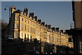
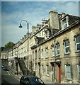
Walcot Parade, Bath
The western end of a bending terrace of 20 houses of about 1760 above the London Road, elevated over a high curving pavement, with basement entrances by the roadway http://www.britishlistedbuildings.co.uk/en-442901-1-15-bath . On the left is Margaret's Hill.
Image: © Derek Harper
Taken: 11 Feb 2012
0.06 miles
2
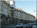
Walcot Parade, London Road, Bath
Fine Georgian terrace, of a standard Bath type, but raised on a very high pavement. Dated c1770. Grade II listed.
Image: © Stephen Richards
Taken: 25 May 2012
0.06 miles
3
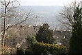
Looking across the valley of the River Avon at Walcot
Across the roofs of houses in Camden Road Walcot.
Image: © Rod Allday
Taken: 4 Mar 2013
0.06 miles
4

At Hedgemead Park (10)
Overlooking London Road
Image: © Anthony O'Neil
Taken: 18 Mar 2023
0.06 miles
5
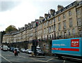
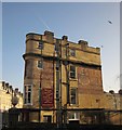
An elevated terrace and an elevated traffic light, Walcot Parade, Bath
Built in about 1770, Walcot Parade is a 130 metre long row of houses on an elevated site on the north side of the A4 London Road. The railings alongside the pavement past the houses are at the same height as the top of the Argos lorry.
Almost as if to match the elevated location of the houses, there is a traffic light very high up, on a pole above another one at a more usual level.
Image: © Jaggery
Taken: 24 Sep 2011
0.06 miles
6
Terrace on London Road
Looking south-southwest from a Bath-bound National Express coach.
Image: © Robert Lamb
Taken: 31 Jul 2011
0.07 miles
7

Hedgemead Park
This five acre recreation area is perched on the slopes above the London Road. It used to have housing on it until a landslide in 1889.
Image: © Neil Owen
Taken: 7 Jan 2014
0.07 miles
8
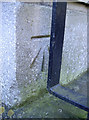
Facing the railings
A benchmark, as listed in the Benchmark Database: http://www.bench-marks.org.uk/bm53855 , on a building beside the old Wesleyan chapel on London Road. See Image] for a look at the latter.
Image: © Neil Owen
Taken: 7 Jan 2014
0.08 miles
9

Houses on the hillside, viewed from the A4
Taken looking north-northwest from a Bath-bound National Express coach.
Image: © Robert Lamb
Taken: 31 Jul 2011
0.08 miles
10
Ghost signs, Bath
On the side of number 1, Cleveland Terrace, which runs along London Road (left). The side road the wall faces is Cleveland Cottages.
Image: © Derek Harper
Taken: 11 Feb 2012
0.08 miles