IMAGES TAKEN NEAR TO
Upper South Wraxall, BRADFORD-ON-AVON, BA15 2SQ
Introduction
This page details the photographs taken nearby to BA15 2SQ by members of the Geograph project.
The Geograph project started in 2005 with the aim of publishing, organising and preserving representative images for every square kilometre of Great Britain, Ireland and the Isle of Man.

There are currently over 7.5m images from over14,400 individuals and you can help contribute to the project by visiting https://www.geograph.org.uk
Image Map
Images are licensed for reuse under creativecommons.org/licenses/by-sa/2.0
Notes
- Clicking on the map will re-center to the selected point.
- The higher the marker number, the further away the image location is from the centre of the postcode.
Image Listing (2 Images Found)
Images are licensed for reuse under creativecommons.org/licenses/by-sa/2.0
Image
Details
Distance
1
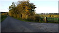
Entrance to New Manor farm
Also a public path to Norbin Barton Farm, visible in the middle distance.
Image: © Jonathan Billinger
Taken: 19 Nov 2013
0.05 miles
2
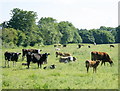
2008 : Herd with calves near South Wraxall
From their appearance these cows would appear to be the mothers of the calves in their care.
This is not always the case, beef calves are sometimes put with cows of an inferior stock which are coming into milk.
Image: © Maurice Pullin
Taken: 7 Jun 2008
0.22 miles