IMAGES TAKEN NEAR TO
Iford Lane, BRADFORD-ON-AVON, BA15 2BD
Introduction
This page details the photographs taken nearby to Iford Lane, BA15 2BD by members of the Geograph project.
The Geograph project started in 2005 with the aim of publishing, organising and preserving representative images for every square kilometre of Great Britain, Ireland and the Isle of Man.

There are currently over 7.5m images from over14,400 individuals and you can help contribute to the project by visiting https://www.geograph.org.uk
Image Map
Images are licensed for reuse under creativecommons.org/licenses/by-sa/2.0
Notes
- Clicking on the map will re-center to the selected point.
- The higher the marker number, the further away the image location is from the centre of the postcode.
Image Listing (5 Images Found)
Images are licensed for reuse under creativecommons.org/licenses/by-sa/2.0
Image
Details
Distance
1
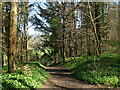
In Friary Wood
Close to the exit onto the flood meadows alongside the Frome. The wood is an old one and has many different species on the hillside.
Image: © Neil Owen
Taken: 29 Mar 2021
0.16 miles
2
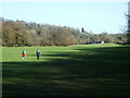
To Iford Mill
The flood meadows by the River Frome as they sweep to the mill.
Image: © Neil Owen
Taken: 29 Mar 2021
0.17 miles
3
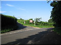
Junction near Westwood
A view looking east along the lane from Westood to Freshford, showing the junction with the lane to Upper Westwood and Avoncliff.
Image: © Phil Williams
Taken: 22 Jun 2006
0.17 miles
4

Friary Wood in Spring
The woodland looking particularly attractive at this time of year!
Image: © Colin Bews
Taken: 3 May 2014
0.20 miles
5

2007 : Staples Hill
Cottages at the top of Staples Hill between Westwood and Freshford.
The water tower on the skyline is a feature of this area.
Image: © Maurice Pullin
Taken: 11 Aug 2007
0.23 miles