IMAGES TAKEN NEAR TO
Lower Westwood, BRADFORD-ON-AVON, BA15 2AW
Introduction
This page details the photographs taken nearby to BA15 2AW by members of the Geograph project.
The Geograph project started in 2005 with the aim of publishing, organising and preserving representative images for every square kilometre of Great Britain, Ireland and the Isle of Man.

There are currently over 7.5m images from over14,400 individuals and you can help contribute to the project by visiting https://www.geograph.org.uk
Image Map
Images are licensed for reuse under creativecommons.org/licenses/by-sa/2.0
Notes
- Clicking on the map will re-center to the selected point.
- The higher the marker number, the further away the image location is from the centre of the postcode.
Image Listing (87 Images Found)
Images are licensed for reuse under creativecommons.org/licenses/by-sa/2.0
Image
Details
Distance
1
All sorts of stone
Perhaps a former gate or reuse of old stones?
Image: © Neil Owen
Taken: 29 Mar 2021
0.03 miles
2

Phone cables along Westwood Road
Set into the pavement is an old G.P.O. marker. See Image
Image: © Neil Owen
Taken: 29 Mar 2021
0.03 miles
3

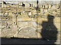
An old G.P.O. marker
Embedded into the pavement on Westwood Road is an old relic of earlier days in telecommunications. Within the pre-cast is a band fitted with imperial measurements. Presumably the access is underneath the concrete. See Image] for a view of the position.
Image: © Neil Owen
Taken: 29 Mar 2021
0.03 miles
4
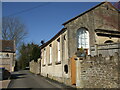
Orchard Close, Westwood
The building to the right is the former Particular Baptist chapel, dating back to the nineteenth century. Local friends met in various houses in the early 1800s, before sufficient money was raised to found this in 1865.
Further on to the left is the hall and former Sunday school.
The church and education were closely combined initially: a Sunday class was established in the chapel in 1871, but when the opportunity arose the new hall and school was built in 1885. Later, the school welcomed infants on a more regular basis but was succeeded after WWII. The chapel was sold off and later became a studio in 1978.
Image: © Neil Owen
Taken: 29 Mar 2021
0.05 miles
6
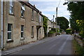
Westwood Social Club
The village has had a hall here for community use for around a century.
Image: © Neil Owen
Taken: 29 Mar 2021
0.08 miles
7
![Four ways to go [1]](https://s3.geograph.org.uk/geophotos/05/88/63/5886343_b4eebef8_120x120.jpg)
Four ways to go [1]
From where the footpaths cross there are four ways to go. This way leads to Haygrove Farm.
Image: © Michael Dibb
Taken: 10 Jul 2018
0.09 miles
8
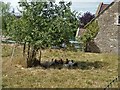
Clucking in the shade
On a hot summer day, even the hens seek the shade. Seen from the footpath.
Image: © Michael Dibb
Taken: 10 Jul 2018
0.09 miles
9
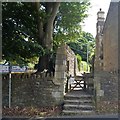
Path meets the road
The footpath ends where it meets Westwood Road.
Image: © Michael Dibb
Taken: 10 Jul 2018
0.10 miles
10
![Four ways to go [2]](https://s1.geograph.org.uk/geophotos/05/88/63/5886345_de199c1c_120x120.jpg)
Four ways to go [2]
From where the footpaths cross there are four ways to go. This way leads to Westwood Road.
Image: © Michael Dibb
Taken: 10 Jul 2018
0.10 miles