IMAGES TAKEN NEAR TO
Whitehill, BRADFORD-ON-AVON, BA15 1SG
Introduction
This page details the photographs taken nearby to Whitehill, BA15 1SG by members of the Geograph project.
The Geograph project started in 2005 with the aim of publishing, organising and preserving representative images for every square kilometre of Great Britain, Ireland and the Isle of Man.

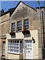
There are currently over 7.5m images from over14,400 individuals and you can help contribute to the project by visiting https://www.geograph.org.uk
Image Map
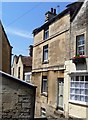
Images are licensed for reuse under creativecommons.org/licenses/by-sa/2.0
Notes
- Clicking on the map will re-center to the selected point.
- The higher the marker number, the further away the image location is from the centre of the postcode.
Image Listing (470 Images Found)
Images are licensed for reuse under creativecommons.org/licenses/by-sa/2.0
Image
Details
Distance
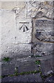
1
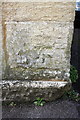
Benchmark on gatepier on #13 Whitehill
Ordnance Survey cut mark benchmark described on the Bench Mark Database at http://www.bench-marks.org.uk/bm65737
Image: © Roger Templeman
Taken: 26 Mar 2015
0.01 miles
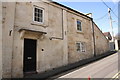
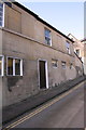
2
#13 Whitehill
There is an OS benchmark Image on the gate pier at the right hand edge of the image.
Image: © Roger Templeman
Taken: 26 Mar 2015
0.01 miles
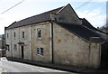
3
#13 Whitehill
There is an OS benchmark Image on the near gate pier of the entrance at the right hand edge of the image
Image: © Roger Templeman
Taken: 26 Mar 2015
0.01 miles
4

9 and 9A Whitehill
The date above the arch is 1897.
Image: © Michael Dibb
Taken: 6 Jul 2018
0.03 miles
5
Number 78 Whitehill
This small cottage is listed, grade II, with details at: https://www.historicengland.org.uk/listing/the-list/list-entry/1184845
Image: © Michael Dibb
Taken: 6 Jul 2018
0.04 miles
6
Bakery Cottage
This late 17th/early 18th century cottage has been a bakers shop. Listed, along with the attached wall to the right, grade II, with details at:
Image: © Michael Dibb
Taken: 6 Jul 2018
0.04 miles
7
Number 7 Whitehill
This early 19th century cottage is listed, grade II, with details at: https://www.historicengland.org.uk/listing/the-list/list-entry/1364477
Image: © Michael Dibb
Taken: 6 Jul 2018
0.04 miles
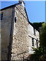
8
Benchmark on #1 Whitehill
Ordnance Survey cut mark benchmark described on the Bench Mark Database at http://www.bench-marks.org.uk/bm65517
Image: © Roger Templeman
Taken: 26 Mar 2015
0.04 miles
9
#1 Whitehill
There is an OS benchmark Image on the front of the house at its far corner (at junction with outbuilding)
Image: © Roger Templeman
Taken: 26 Mar 2015
0.04 miles
10
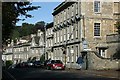
2007 : Woolley Street, Bradford on Avon
This is the "town" end of Woolley Street which forms an end-on junction with Silver Street near the left hand edge of the picture. See Image] for a view further along Woolley Street.
Image: © Maurice Pullin
Taken: 18 Oct 2007
0.05 miles