IMAGES TAKEN NEAR TO
Newtown, BRADFORD-ON-AVON, BA15 1NF
Introduction
This page details the photographs taken nearby to Newtown, BA15 1NF by members of the Geograph project.
The Geograph project started in 2005 with the aim of publishing, organising and preserving representative images for every square kilometre of Great Britain, Ireland and the Isle of Man.

There are currently over 7.5m images from over14,400 individuals and you can help contribute to the project by visiting https://www.geograph.org.uk
Image Map
Images are licensed for reuse under creativecommons.org/licenses/by-sa/2.0
Notes
- Clicking on the map will re-center to the selected point.
- The higher the marker number, the further away the image location is from the centre of the postcode.
Image Listing (627 Images Found)
Images are licensed for reuse under creativecommons.org/licenses/by-sa/2.0
Image
Details
Distance
1
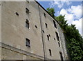
Starred wall
The wall-braces in the old malthouse buildings have a rather appealing star form.
Image: © Neil Owen
Taken: 25 Jun 2014
0.01 miles
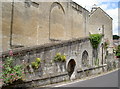
2
![The Old Brewery [2]](https://s2.geograph.org.uk/geophotos/05/83/24/5832490_f273f512_120x120.jpg)
The Old Brewery [2]
Built in the 19th century in an old quarry, The Old Brewery is now flats with workshops below. Standing essentially as built, this important building has traces of Neoclassism and is described by English Heritage as 'Piranesian grandeur'. The building and the wall around the forecourt are listed, grade II, with details at: https://www.historicengland.org.uk/listing/the-list/list-entry/1036164
Image: © Michael Dibb
Taken: 19 Jun 2018
0.01 miles
3
![The Old Brewery [1]](https://s1.geograph.org.uk/geophotos/05/83/24/5832489_63af548c_120x120.jpg)
The Old Brewery [1]
Built in the 19th century in an old quarry, The Old Brewery is now flats with workshops below. Standing essentially as built, this important building has traces of Neoclassism and is described by English Heritage as 'Piranesian grandeur'. The building and the wall around the forecourt are listed, grade II, with details at: https://www.historicengland.org.uk/listing/the-list/list-entry/1036164
Image: © Michael Dibb
Taken: 19 Jun 2018
0.01 miles
4
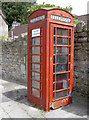
Newtown box
A familiar phone box, bearing the words that have become a byword for the twenty-first century: "Coins Not Accepted Here'.
Note the poor condition of the wooden door.
Image: © Neil Owen
Taken: 25 Jun 2014
0.02 miles
5
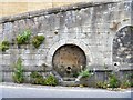
Lady Well
The well is below a ramped path known as well path, an ancient route from Budbury to Barton Bridge. The 19th century ramped path is listed, grade II, with details at: https://www.historicengland.org.uk/listing/the-list/list-entry/1300264
Image: © Michael Dibb
Taken: 19 Jun 2018
0.02 miles
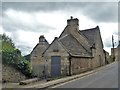
6
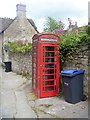
Telephone box
A K6 box. Listed, grade II, with details at: https://www.historicengland.org.uk/listing/the-list/list-entry/1036166
Image: © Michael Dibb
Taken: 19 Jun 2018
0.02 miles
7
Well in Newtown
The steep slopes overlooking the town of Bradford-on-Avon are home to St Mary's Tory church; it is also associated with a hermitage and a well, which was an important source of public water in the past. The waters emerge form the wall of the steps here and is known as Pilgrim's Well or Ladywell.
Image: © Neil Owen
Taken: 25 Jun 2014
0.02 miles
8
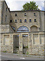
The old Malthouse
Once a busy malthouse and then a builder's yard, these lofty structures are now a small commercial estate with a number of small businesses in it.
Image: © Neil Owen
Taken: 25 Jun 2014
0.02 miles
9
Houses above houses, Bradford-on-Avon
A view west from Newtown towards higher ground.
Image: © Jaggery
Taken: 7 Oct 2011
0.02 miles
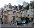
10
5 & 6 Newtown
Number 6 appears to be named Ladywell. Number 5 is listed, grade II, with details at: https://www.historicengland.org.uk/listing/the-list/list-entry/1184143
Image: © Michael Dibb
Taken: 19 Jun 2018
0.02 miles