IMAGES TAKEN NEAR TO
Newtown, BRADFORD-ON-AVON, BA15 1NE
Introduction
This page details the photographs taken nearby to Newtown, BA15 1NE by members of the Geograph project.
The Geograph project started in 2005 with the aim of publishing, organising and preserving representative images for every square kilometre of Great Britain, Ireland and the Isle of Man.

There are currently over 7.5m images from over14,400 individuals and you can help contribute to the project by visiting https://www.geograph.org.uk
Image Map
Images are licensed for reuse under creativecommons.org/licenses/by-sa/2.0
Notes
- Clicking on the map will re-center to the selected point.
- The higher the marker number, the further away the image location is from the centre of the postcode.
Image Listing (533 Images Found)
Images are licensed for reuse under creativecommons.org/licenses/by-sa/2.0
Image
Details
Distance
1
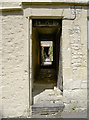
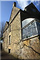
Through the door
A look through a doorway to a courtyard beyond in Belcombe Road.
Image: © Neil Owen
Taken: 25 Jun 2014
0.01 miles
2
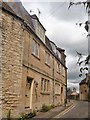
17 and 18 Newtown
These two 17th/18th century houses are listed, grade II, with details at: https://www.historicengland.org.uk/listing/the-list/list-entry/1036083
Image: © Michael Dibb
Taken: 19 Jun 2018
0.01 miles
3
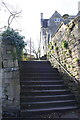
Steps from Barton Orchard to Newtown
There is an OS benchmark Image at the base of the wall on the left hand side of the steps
Image: © Roger Templeman
Taken: 31 Mar 2015
0.01 miles
4
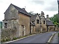
10 and 10B Newtown
These 17th century with early 18th century additions are listed, grade II, with details at: https://www.historicengland.org.uk/listing/the-list/list-entry/1300257
Image: © Michael Dibb
Taken: 19 Jun 2018
0.01 miles
5
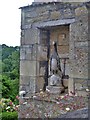
Newtown penguin
A delightful stone penguin in a niche in 10B Newtown.
Image: © Michael Dibb
Taken: 19 Jun 2018
0.01 miles
6
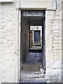
The way through
The passageway divides numbers 14 and 16 Newtown. Both 17th century houses are listed with details at: https://www.historicengland.org.uk/listing/the-list/list-entry/1300261
Image: © Michael Dibb
Taken: 19 Jun 2018
0.02 miles
7
Benchmark on #10 Newtown
Ordnance Survey cut mark benchmark described on the Bench Mark Database at http://www.bench-marks.org.uk/bm65865
Image: © Roger Templeman
Taken: 31 Mar 2015
0.02 miles
8
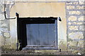
South face of #10 Newtown beside path from Barton Orchard
There is an Ordnance Survey Image on the right hand side of the ground level hatch
Image: © Roger Templeman
Taken: 31 Mar 2015
0.02 miles
9
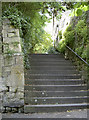
Steps to Belcombe Road
A short flight to the road above, or a right turn will take you to Barton Orchard. Look closer and you will see a benchmark on the wall - Image
Image: © Neil Owen
Taken: 25 Jun 2014
0.02 miles
10
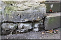
Benchmark on wall of Barton Orchard
Ordnance Survey cut mark benchmark described on the Bench Mark Database at http://www.bench-marks.org.uk/bm58800
Image: © Roger Templeman
Taken: 31 Mar 2015
0.02 miles