IMAGES TAKEN NEAR TO
St. Margarets Villas, BRADFORD-ON-AVON, BA15 1DU
Introduction
This page details the photographs taken nearby to St. Margarets Villas, BA15 1DU by members of the Geograph project.
The Geograph project started in 2005 with the aim of publishing, organising and preserving representative images for every square kilometre of Great Britain, Ireland and the Isle of Man.

There are currently over 7.5m images from over14,400 individuals and you can help contribute to the project by visiting https://www.geograph.org.uk
Image Map
Images are licensed for reuse under creativecommons.org/licenses/by-sa/2.0
Notes
- Clicking on the map will re-center to the selected point.
- The higher the marker number, the further away the image location is from the centre of the postcode.
Image Listing (623 Images Found)
Images are licensed for reuse under creativecommons.org/licenses/by-sa/2.0
Image
Details
Distance
1
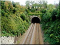
Western portal of a railway tunnel, Bradford-on-Avon
The tunnel through St Margaret's Hill was built in 1848 to the design of Isambard Kingdom Brunel. Bradford-on-Avon railway station is about 150 metres behind the camera.
Image: © Jaggery
Taken: 7 Oct 2011
0.04 miles
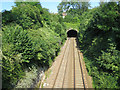
2
Two bridges and a tunnel, Bradford-on-Avon
A view east from platform 1 at Bradford-on-Avon railway station.
Beyond the Frome Road bridge and St Margarets Street bridge
is a 135 metre long tunnel through St Margaret's Hill.
Image: © Jaggery
Taken: 7 Oct 2011
0.04 miles
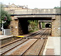
3
Entrance to railway tunnel
Taken from St Margaret's Street, the eastbound railway heads towards Trowbridge.
Image: © Stuart Logan
Taken: 24 Jul 2014
0.04 miles
4
St Margaret's Surgery, Bradford-on-Avon
Located in Bridge Street on the south bank of the River Avon.
Image: © Jaggery
Taken: 7 Oct 2011
0.04 miles
5
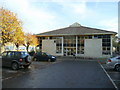
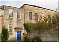
Bradford-on-Avon library and museum 1
Pictured from the west on a November day.
Image: © Jonathan Billinger
Taken: 19 Nov 2008
0.05 miles
6
![Railway station [3]](https://s3.geograph.org.uk/geophotos/07/40/61/7406155_b8bd8836_120x120.jpg)
Railway station [3]
Looking along the lines in the direction of Trowbridge from the platform at Bradford-on-Avon station. The first bridge carries Frome Road, the second bridge carries St Margaret's Street. Beyond, a short tunnel leads to a bridge over the River Avon.
The walk starts at Trowbridge railway station and initially follows both the railway line and the River Bliss northwards. The river and the railway both pass under the Kennet and Avon Canal and the canal towpath is taken heading west towards Bradford-on-Avon. Leaving the canal, a short walk through streets leads to the railway station for a train back to the starting point at Trowbridge. Just under 3¾ miles.
Image: © Michael Dibb
Taken: 26 Jan 2023
0.05 miles
8
Longs Yard, Bradford-on-Avon
Modern housing set back from the east side of the A363.
Image: © Jaggery
Taken: 7 Oct 2011
0.06 miles
9
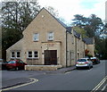
United Church, Bradford-on-Avon
Set back from St Margaret's Hill near the corner of St Margaret's Street.
The church's website states that the building dates from 1740, when it was an Independent Meeting House. It was later the Congregational Church which became the United Reformed Church when the Presbyterians joined with the Congregationalists in 1972.
In 1974 the Methodists in Bradford-on-Avon also started to worship here when their church
at Coppice Hill fell into disrepair. A shared building agreement was entered into in 1976.
In 1981 the church became formally known as the United Church (Methodist and URC).
Image: © Jaggery
Taken: 7 Oct 2011
0.06 miles