IMAGES TAKEN NEAR TO
Orchard Gardens, BRADFORD-ON-AVON, BA15 1BN
Introduction
This page details the photographs taken nearby to Orchard Gardens, BA15 1BN by members of the Geograph project.
The Geograph project started in 2005 with the aim of publishing, organising and preserving representative images for every square kilometre of Great Britain, Ireland and the Isle of Man.

There are currently over 7.5m images from over14,400 individuals and you can help contribute to the project by visiting https://www.geograph.org.uk
Image Map
Images are licensed for reuse under creativecommons.org/licenses/by-sa/2.0
Notes
- Clicking on the map will re-center to the selected point.
- The higher the marker number, the further away the image location is from the centre of the postcode.
Image Listing (412 Images Found)
Images are licensed for reuse under creativecommons.org/licenses/by-sa/2.0
Image
Details
Distance
1
Longs Yard, Bradford-on-Avon
Modern housing set back from the east side of the A363.
Image: © Jaggery
Taken: 7 Oct 2011
0.05 miles
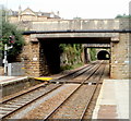
2

2007 : Railway Tunnel, Bradford on Avon
Viewed from the level crossing on the road to Greenland Mills, the Station is about 200 yards beyond the far end of the tunnel.
Image] gives a view from a pedestrian crossing in the far distance looking this way.
Image: © Maurice Pullin
Taken: 18 Oct 2007
0.07 miles
3
Regents Place, Bradford-on-Avon
Viewed from the Trowbridge Road end looking towards Upper Regents Park.
Image: © Jaggery
Taken: 7 Oct 2011
0.08 miles
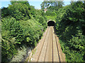
4
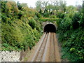
Western portal of a railway tunnel, Bradford-on-Avon
The tunnel through St Margaret's Hill was built in 1848 to the design of Isambard Kingdom Brunel. Bradford-on-Avon railway station is about 150 metres behind the camera.
Image: © Jaggery
Taken: 7 Oct 2011
0.08 miles
5
Two bridges and a tunnel, Bradford-on-Avon
A view east from platform 1 at Bradford-on-Avon railway station.
Beyond the Frome Road bridge and St Margarets Street bridge
is a 135 metre long tunnel through St Margaret's Hill.
Image: © Jaggery
Taken: 7 Oct 2011
0.08 miles
6
Entrance to railway tunnel
Taken from St Margaret's Street, the eastbound railway heads towards Trowbridge.
Image: © Stuart Logan
Taken: 24 Jul 2014
0.08 miles
7
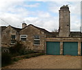
Large chimney stack, a relic of a former iron foundry, Bradford-on-Avon
Viewed from Regents Place. The chimney stack is a reminder of the industrial activity that formerly took place in this now quiet residential area.
Image: © Jaggery
Taken: 7 Oct 2011
0.08 miles
8

Trowbridge Road houses, Bradford-on-Avon
Viewed from near the Regents Place junction looking towards the town centre.
Image: © Jaggery
Taken: 7 Oct 2011
0.09 miles
9
![Railway station [3]](https://s3.geograph.org.uk/geophotos/07/40/61/7406155_b8bd8836_120x120.jpg)
Railway station [3]
Looking along the lines in the direction of Trowbridge from the platform at Bradford-on-Avon station. The first bridge carries Frome Road, the second bridge carries St Margaret's Street. Beyond, a short tunnel leads to a bridge over the River Avon.
The walk starts at Trowbridge railway station and initially follows both the railway line and the River Bliss northwards. The river and the railway both pass under the Kennet and Avon Canal and the canal towpath is taken heading west towards Bradford-on-Avon. Leaving the canal, a short walk through streets leads to the railway station for a train back to the starting point at Trowbridge. Just under 3¾ miles.
Image: © Michael Dibb
Taken: 26 Jan 2023
0.09 miles