IMAGES TAKEN NEAR TO
Sand Close, BRADFORD-ON-AVON, BA15 1BJ
Introduction
This page details the photographs taken nearby to Sand Close, BA15 1BJ by members of the Geograph project.
The Geograph project started in 2005 with the aim of publishing, organising and preserving representative images for every square kilometre of Great Britain, Ireland and the Isle of Man.

There are currently over 7.5m images from over14,400 individuals and you can help contribute to the project by visiting https://www.geograph.org.uk
Image Map
Images are licensed for reuse under creativecommons.org/licenses/by-sa/2.0
Notes
- Clicking on the map will re-center to the selected point.
- The higher the marker number, the further away the image location is from the centre of the postcode.
Image Listing (58 Images Found)
Images are licensed for reuse under creativecommons.org/licenses/by-sa/2.0
Image
Details
Distance
1
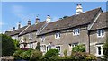
3 to 13 New Road
A fine row of late 17th century cottages. Listed, grade II, with details at: https://www.historicengland.org.uk/listing/the-list/list-entry/1364526
Image: © Michael Dibb
Taken: 6 Jul 2018
0.08 miles
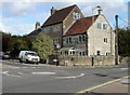
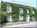
2
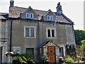
Hill House
This late 17th/early 18th century house has not fared well with the extensions and alterations. Listed, grade II, with details at: https://www.historicengland.org.uk/listing/the-list/list-entry/1364473
Image: © Michael Dibb
Taken: 6 Jul 2018
0.11 miles
3
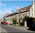
Sladesbrook houses, Bradford-on-Avon
Sladesbrook is a road at the NE edge of Bradford-on-Avon.
Image: © Jaggery
Taken: 7 Oct 2011
0.11 miles
4
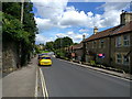
Corner of New Road and Sladesbrook, Bradford-on-Avon
View across a mini-roundabout at a road junction in the NE of Bradford-on-Avon.
Image: © Jaggery
Taken: 7 Oct 2011
0.12 miles
5
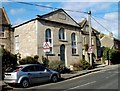
Former chapel, Sladesbrook, Bradford-on-Avon
Now a private residence, built in 1845 as a Primitive Methodist Chapel. After the chapel became disused c1890, it was a temperance hall for a time and was later used by Christ Church School.
Image: © Jaggery
Taken: 7 Oct 2011
0.12 miles
6
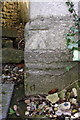
Benchmark on 'The Old Chapel'
Ordnance Survey cut mark benchmark described on the Bench Mark Database at http://www.bench-marks.org.uk/bm65514
Image: © Roger Templeman
Taken: 26 Mar 2015
0.12 miles
7
'The Old Chapel', #3 Sladesbrook
There is an OS benchmark Image on the front of the house between the two wheelie bins
Image: © Roger Templeman
Taken: 26 Mar 2015
0.12 miles
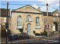
8
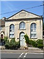
Former chapel
This former Primitive Methodist chapel built in 1845 was recently used as part of the local school. Listed, grade II, with details at: https://www.historicengland.org.uk/listing/the-list/list-entry/1299977
Image: © Michael Dibb
Taken: 6 Jul 2018
0.12 miles
9
Eastcott House
Located at number 5 Sladesbrook.
Image: © Michael Dibb
Taken: 6 Jul 2018
0.13 miles