IMAGES TAKEN NEAR TO
Fleur De Lys Drive, TROWBRIDGE, BA14 9QH
Introduction
This page details the photographs taken nearby to Fleur De Lys Drive, BA14 9QH by members of the Geograph project.
The Geograph project started in 2005 with the aim of publishing, organising and preserving representative images for every square kilometre of Great Britain, Ireland and the Isle of Man.

There are currently over 7.5m images from over14,400 individuals and you can help contribute to the project by visiting https://www.geograph.org.uk
Image Map
Images are licensed for reuse under creativecommons.org/licenses/by-sa/2.0
Notes
- Clicking on the map will re-center to the selected point.
- The higher the marker number, the further away the image location is from the centre of the postcode.
Image Listing (27 Images Found)
Images are licensed for reuse under creativecommons.org/licenses/by-sa/2.0
Image
Details
Distance
1
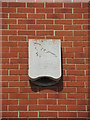
Batman's house?
High on the end wall of a house near Fleur de Lys Drive is a rather peculiar object. What might at first glance be a burglar alarm box actually has a bat motif in relief and a pattern on it. Further investigation reveals it is a product made by Schwegler - a firm renowned for producing bird and bat boxes.
Image: © Neil Owen
Taken: 4 Aug 2022
0.03 miles
2
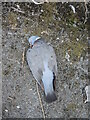
Dead woody
A poor Wood Pigeon (Columba palumbus) has flown its last and rests behind the garages in Chantry Gardens. It looks quite fresh and without obvious injuries
Image: © Neil Owen
Taken: 4 Aug 2022
0.04 miles
3
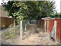
Chantry Gardens substation
A small electricity unit, tucked away in its own track. It is part of the post-war housing estate that expanded Southwick significantly in the modern era.
Image: © Neil Owen
Taken: 4 Aug 2022
0.05 miles
4
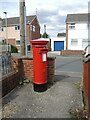
Letterbox off Chantry Gardens
This one is partly protected by a low wall and is on an alleyway behind the houses.
Image: © Neil Owen
Taken: 4 Aug 2022
0.06 miles
5

2007 : Grove Farm, Southwick
The farmhouse appears to have been converted for residential purposes, there is new housing on either side and the land behind has been taken over by the Southwick Country Park - worth a visit.
Image: © Maurice Pullin
Taken: 15 Dec 2007
0.07 miles
6

2007 : The Farmhouse Inn, Southwick
The only public house remaining in Southwick (that I know of).
Image: © Maurice Pullin
Taken: 15 Dec 2007
0.08 miles
7
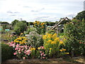
Southwick allotments
Located behind the Farmhouse Inn and further on, the allotments occupy a large area and has all sorts of things growing in them.
Image: © Neil Owen
Taken: 4 Aug 2022
0.08 miles
8
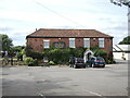
The Farmhouse Inn, Southwick
The building is essentially an old farmhouse (the eighteenth century Southwick Farm) which was converted into a restaurant in the 1970s. Grade II listed.
Image: © Neil Owen
Taken: 4 Aug 2022
0.08 miles
9
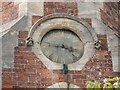
Southwick School clock
The tower has clock faces to keep the school day running along. Despite the school closing in 1975, time is still kept. See Image] for a wider view of the old school.
Image: © Neil Owen
Taken: 4 Aug 2022
0.12 miles
10
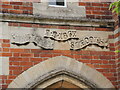
Inscribed on the school tower
Southwick National School was founded in 1867. It was enlarged in 1898 to hold some 200 pupils and was the only source of education for all the village's children until 1931, when only younger ones were admitted. It finally closed in 1975. See Image] for another detail.
Image: © Neil Owen
Taken: 4 Aug 2022
0.12 miles