IMAGES TAKEN NEAR TO
Frome Road, TROWBRIDGE, BA14 9QF
Introduction
This page details the photographs taken nearby to Frome Road, BA14 9QF by members of the Geograph project.
The Geograph project started in 2005 with the aim of publishing, organising and preserving representative images for every square kilometre of Great Britain, Ireland and the Isle of Man.

There are currently over 7.5m images from over14,400 individuals and you can help contribute to the project by visiting https://www.geograph.org.uk
Image Map
Images are licensed for reuse under creativecommons.org/licenses/by-sa/2.0
Notes
- Clicking on the map will re-center to the selected point.
- The higher the marker number, the further away the image location is from the centre of the postcode.
Image Listing (41 Images Found)
Images are licensed for reuse under creativecommons.org/licenses/by-sa/2.0
Image
Details
Distance
1
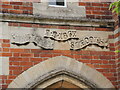
Inscribed on the school tower
Southwick National School was founded in 1867. It was enlarged in 1898 to hold some 200 pupils and was the only source of education for all the village's children until 1931, when only younger ones were admitted. It finally closed in 1975. See Image] for another detail.
Image: © Neil Owen
Taken: 4 Aug 2022
0.03 miles
2
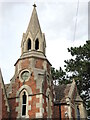
School spire
Quite an unusual design, the school has a clock tower with a short octagonal spire. See Image] for another look.
Image: © Neil Owen
Taken: 4 Aug 2022
0.03 miles
3
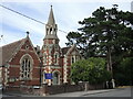
Southwick's old school
A fine Gothic style building on the Frome Road was the school. It was a National School, built in 1867 on land donated by the Conservative M.P. Richard Penruddocke Long. It served until 1975, whereupon the pupils were sent to a new school. See Image] for a detail.
Image: © Neil Owen
Taken: 4 Aug 2022
0.03 miles
4
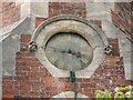
Southwick School clock
The tower has clock faces to keep the school day running along. Despite the school closing in 1975, time is still kept. See Image] for a wider view of the old school.
Image: © Neil Owen
Taken: 4 Aug 2022
0.03 miles
5

The old Providence Chapel
Now a private residence, the chapel was founded in 1861. Southwick was a largely agricultural village for centuries with additional work in the form of hand weaving for a time. However, the area was not particularly rich and against this background the Baptist movement took hold from the 1770s onwards. It became a stronghold for the faith and there are a number of churches still evident.
However, the movement also had disagreements and so a Calvinist breakaway group founded the society of strict Baptists; this was the church they worshipped in. Grade II listed.
Image: © Neil Owen
Taken: 4 Aug 2022
0.04 miles
6
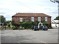
The Farmhouse Inn, Southwick
The building is essentially an old farmhouse (the eighteenth century Southwick Farm) which was converted into a restaurant in the 1970s. Grade II listed.
Image: © Neil Owen
Taken: 4 Aug 2022
0.07 miles
7

2007 : The Farmhouse Inn, Southwick
The only public house remaining in Southwick (that I know of).
Image: © Maurice Pullin
Taken: 15 Dec 2007
0.07 miles
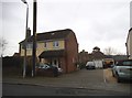
9
2007 : The road to North Bradley
Southwick is hardly a place of outstanding beauty, natural or otherwise. This is about as good as it gets, but it is still better than Slough.
The mini roundabout is at the junction of the A361 (Trowbridge to Beckington) and the road to North Bradley. You could call it the heart of the village.
Image: © Maurice Pullin
Taken: 15 Dec 2007
0.08 miles
10
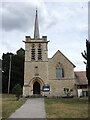
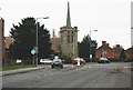
Church of St Thomas, Southwick
The church stands at a prominent junction of the Frome Road. It was founded and built in 1899-1904 to designs by C. E. Ponting. His work is largely Gothic but with other features more in style of Arts and Crafts such as splayed buttressing, exaggerated eaves, the four-square tower and its stonework. The tower itself is surmounted by a fleche, which is covered with oak shingles. See Image] for a closer look at them. Grade II listed.
Image: © Neil Owen
Taken: 4 Aug 2022
0.10 miles