IMAGES TAKEN NEAR TO
Frome Road, TROWBRIDGE, BA14 9LS
Introduction
This page details the photographs taken nearby to Frome Road, BA14 9LS by members of the Geograph project.
The Geograph project started in 2005 with the aim of publishing, organising and preserving representative images for every square kilometre of Great Britain, Ireland and the Isle of Man.

There are currently over 7.5m images from over14,400 individuals and you can help contribute to the project by visiting https://www.geograph.org.uk
Image Map
Images are licensed for reuse under creativecommons.org/licenses/by-sa/2.0
Notes
- Clicking on the map will re-center to the selected point.
- The higher the marker number, the further away the image location is from the centre of the postcode.
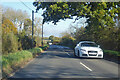
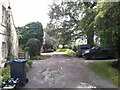
Image Listing (4 Images Found)
Images are licensed for reuse under creativecommons.org/licenses/by-sa/2.0
Image
Details
Distance
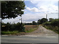
1
Bend on B3109 Bradford Road
Towards Bradford-on-Avon, at the end of a very long (over 2 km) straight.
Image: © Robin Webster
Taken: 13 Nov 2022
0.01 miles
3
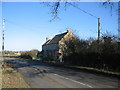
Pomeroy Cottage
A view looking northeast along the B3109 Bradford Road towards Pomeroy Cottage and the start of the bridleway to Hogginton.
Image: © Phil Williams
Taken: 29 Jan 2006
0.05 miles