IMAGES TAKEN NEAR TO
Ashton Road, TROWBRIDGE, BA14 7TH
Introduction
This page details the photographs taken nearby to Ashton Road, BA14 7TH by members of the Geograph project.
The Geograph project started in 2005 with the aim of publishing, organising and preserving representative images for every square kilometre of Great Britain, Ireland and the Isle of Man.

There are currently over 7.5m images from over14,400 individuals and you can help contribute to the project by visiting https://www.geograph.org.uk
Image Map
Images are licensed for reuse under creativecommons.org/licenses/by-sa/2.0
Notes
- Clicking on the map will re-center to the selected point.
- The higher the marker number, the further away the image location is from the centre of the postcode.
Image Listing (7 Images Found)
Images are licensed for reuse under creativecommons.org/licenses/by-sa/2.0
Image
Details
Distance
2
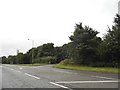
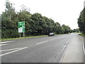
A361 Hilperton Drive
Bypassing Hilperton, towards Devizes.
Image: © Robin Webster
Taken: 30 May 2021
0.11 miles
5
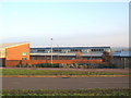
The Mead County Primary school
Looking east at the Mead County Primary school, serving the Paxcroft Mead development near Trowbridge.
Image: © Phil Williams
Taken: 11 Dec 2005
0.21 miles