IMAGES TAKEN NEAR TO
Horse Road, TROWBRIDGE, BA14 7PE
Introduction
This page details the photographs taken nearby to Horse Road, BA14 7PE by members of the Geograph project.
The Geograph project started in 2005 with the aim of publishing, organising and preserving representative images for every square kilometre of Great Britain, Ireland and the Isle of Man.

There are currently over 7.5m images from over14,400 individuals and you can help contribute to the project by visiting https://www.geograph.org.uk
Image Map
Images are licensed for reuse under creativecommons.org/licenses/by-sa/2.0
Notes
- Clicking on the map will re-center to the selected point.
- The higher the marker number, the further away the image location is from the centre of the postcode.
Image Listing (13 Images Found)
Images are licensed for reuse under creativecommons.org/licenses/by-sa/2.0
Image
Details
Distance
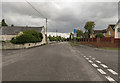
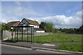
2

2007 : Horse Road, Hilperton Marsh
A link with Trowbridge.
Image: © Maurice Pullin
Taken: 23 Nov 2007
0.14 miles
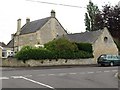
3
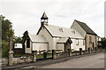
St Mary Magdalene Church, Hilperton
Also known as The Tin Church, it was built as a chapel of ease to St. Michael's church at Hilperton in 1899.It was ordered prefabricated and erected on land given by Lord Long.
Later on money was given for a stone church, but it was insufficient, and only half was built, attached to the Tin Church.
It is still in use today.
Info: Wiltshire Council.
Image: © Julian P Guffogg
Taken: 17 Aug 2019
0.16 miles
4

Footbridge over stream on Hilperton Marsh
Image: © David Smith
Taken: 7 Jun 2017
0.16 miles
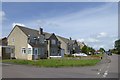
6

2007 : Millards Close, Hilperton Marsh
Hilperton Marsh is not just a collection of Queen Victoria's leftovers, it has to bear its share of modern developments and here is the proof.
Not a bad one as they go, one is almost inclined to give it encouragement.
Image: © Maurice Pullin
Taken: 23 Nov 2007
0.19 miles
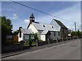
7

Hilperton Marsh
The spire of the village church is in the distance. The nearby hedge marks a stream across the marsh
Image: © David Smith
Taken: 7 Jun 2017
0.20 miles
9
The Poplars, Trowbridge
A C19 house http://www.britishlistedbuildings.co.uk/en-314199-the-poplars-166-trowbridge and stable block http://www.britishlistedbuildings.co.uk/en-314200-stable-block-and-gate-piers-to-no-166-th now surrounded by a housing estate, seen across the junction of Saxon Drive and Wyke Road.
Image: © Derek Harper
Taken: 20 Jul 2011
0.23 miles