IMAGES TAKEN NEAR TO
Ashton Street, TROWBRIDGE, BA14 7ER
Introduction
This page details the photographs taken nearby to Ashton Street, BA14 7ER by members of the Geograph project.
The Geograph project started in 2005 with the aim of publishing, organising and preserving representative images for every square kilometre of Great Britain, Ireland and the Isle of Man.

There are currently over 7.5m images from over14,400 individuals and you can help contribute to the project by visiting https://www.geograph.org.uk
Image Map
Images are licensed for reuse under creativecommons.org/licenses/by-sa/2.0
Notes
- Clicking on the map will re-center to the selected point.
- The higher the marker number, the further away the image location is from the centre of the postcode.
Image Listing (145 Images Found)
Images are licensed for reuse under creativecommons.org/licenses/by-sa/2.0
Image
Details
Distance
1
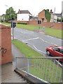
Pedestrian crossing, County Way, Trowbridge
The truncated Ashton Street (see Image) lies on either side of the A361 bypass road; pedestrians must descend, cross the road and climb again.
Image: © Derek Harper
Taken: 20 Jul 2011
0.01 miles
2
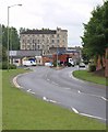
County Way, Trowbridge
The A361 inner ring road curves towards Ashton Mills http://www.britishlistedbuildings.co.uk/en-314187-ashton-mills-trowbridge . The former woollen mill now houses engineering units.
Image: © Derek Harper
Taken: 20 Jul 2011
0.01 miles
3
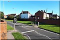
County Way, Trowbridge
At the point where Ashton Street has been cut into two disconnected parts by the construction of the town centre ring road.
Image: © David Martin
Taken: 1 Oct 2018
0.01 miles
4
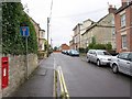
Ashton Street, Trowbridge
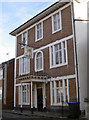
A street truncated (where the brick wall crosses) by the construction of the County Way A361 bypass. The three-storey building on the right is the former Castle public house http://www.britishlistedbuildings.co.uk/en-313872-the-castle-public-house-8-trowbridge .
Image: © Derek Harper
Taken: 20 Jul 2011
0.02 miles
5
The Castle Inn
A small but homely former inn in Ashton Street, and over a century old. See Image] for a look at the sign.
Image: © Neil Owen
Taken: 26 Nov 2013
0.03 miles
6

Old sign
The sign of the Castle Inn in Aston Street; the inn itself is no longer serving pints though. See Image] for a wider view.
Image: © Neil Owen
Taken: 26 Nov 2013
0.03 miles
7

Autumn's gift to the area
Polebarn Road has a number of interesting buildings. This one is Homefield House, a Bath stone work of about 1800. It has been a part of the council network for many years, and is currently a Social Security office. The trees are a welcome sight this time of year.
Image: © Neil Owen
Taken: 26 Nov 2013
0.06 miles
8
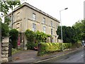
Rosefield House, Trowbridge
With Homefield, a "late C18 / early C19 pair of houses" http://www.britishlistedbuildings.co.uk/en-314102-rosefield-and-homefield-with-gatepiers-g on Polebarn Road.
Image: © Derek Harper
Taken: 20 Jul 2011
0.06 miles
9

Roundabout on County Way, Trowbridge
The rain wasn't friendly to photography and meant changing to the small camera to keep it off the lens. You can just see the Magnet store on the right.
Image: © David Howard
Taken: 21 Aug 2016
0.07 miles
10

Magnet, Trowbridge
Located on Polebarn Road. Left entrance for the kitchen showroom; right entrance for professional trade customers.
Image: © Jaggery
Taken: 5 Dec 2011
0.08 miles