IMAGES TAKEN NEAR TO
Ground Corner, TROWBRIDGE, BA14 6RT
Introduction
This page details the photographs taken nearby to Ground Corner, BA14 6RT by members of the Geograph project.
The Geograph project started in 2005 with the aim of publishing, organising and preserving representative images for every square kilometre of Great Britain, Ireland and the Isle of Man.

There are currently over 7.5m images from over14,400 individuals and you can help contribute to the project by visiting https://www.geograph.org.uk
Image Map
Images are licensed for reuse under creativecommons.org/licenses/by-sa/2.0
Notes
- Clicking on the map will re-center to the selected point.
- The higher the marker number, the further away the image location is from the centre of the postcode.
Image Listing (200 Images Found)
Images are licensed for reuse under creativecommons.org/licenses/by-sa/2.0
Image
Details
Distance
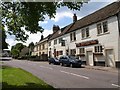
1
![Holt features [3]](https://s0.geograph.org.uk/geophotos/06/41/42/6414244_bf56354d_120x120.jpg)
Holt features [3]
Holt Playing Fields with a game of football seen in the distance.
Two miles north east of Bradford-on-Avon the village of Holt originally consisted of a settlement around the church and an area around a triangular green called The Ham. The village greatly expanded in the later 20th century. Primarily an agricultural village, it was briefly a spa and there was a woollen cloth mill and factories producing leather, gloves and beds. Now a commuter village with workers travelling to Melksham, Trowbridge and Bradford-on-Avon.
Image: © Michael Dibb
Taken: 7 Mar 2020
0.04 miles
2
![Holt houses [16]](https://s1.geograph.org.uk/geophotos/06/41/52/6415221_ebcc10c9_120x120.jpg)
Holt houses [16]
Ostlers House, number 71 Ham Green, was built circa 1700 aith a single storey 19th century extension on the right. Some original internal features survive. Listed, grade II, with details at: https://historicengland.org.uk/listing/the-list/list-entry/1194449
Two miles north east of Bradford-on-Avon the village of Holt originally consisted of a settlement around the church and an area around a triangular green called The Ham. The village greatly expanded in the later 20th century. Primarily an agricultural village, it was briefly a spa and there was a woollen cloth mill and factories producing leather, gloves and beds. Now a commuter village with workers travelling to Melksham, Trowbridge and Bradford-on-Avon.
Image: © Michael Dibb
Taken: 7 Mar 2020
0.06 miles
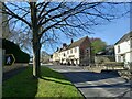
3
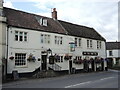
The Old Ham Tree Inn, Ham Green
The late C18 pub, shown in Image, is on the B3107 on the west side of Holt. http://www.imagesofengland.org.uk/details/default.aspx?id=314503 . Beyond it is Marlborough House, of similar age. http://www.imagesofengland.org.uk/details/default.aspx?id=314502
Image: © Derek Harper
Taken: 29 May 2009
0.06 miles
4
![Holt houses [17]](https://s3.geograph.org.uk/geophotos/06/41/52/6415223_901a7518_120x120.jpg)
Holt houses [17]
Number 70 Ham Green comprises two cottages now combined into one house. Built in the late 18th century with a 19th century rear addition. Some original internal features survive. Listed, grade II, with details at: https://historicengland.org.uk/listing/the-list/list-entry/1364096
Two miles north east of Bradford-on-Avon the village of Holt originally consisted of a settlement around the church and an area around a triangular green called The Ham. The village greatly expanded in the later 20th century. Primarily an agricultural village, it was briefly a spa and there was a woollen cloth mill and factories producing leather, gloves and beds. Now a commuter village with workers travelling to Melksham, Trowbridge and Bradford-on-Avon.
Image: © Michael Dibb
Taken: 7 Mar 2020
0.06 miles
6
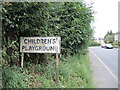
Children's playground sign
An old sign outside the recreation ground, complete with an apostrophe.
Image: © Neil Owen
Taken: 16 Aug 2021
0.06 miles
7
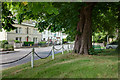
The Old Ham Tree and not the old Ham Tree
The white building in this image is the Old Ham Tree which is a rather pleasant pub opposite the Ham Green. The pub, built in the late 18th century and originally named the New Inn, was apparently named after the large elm tree which grew opposite it on the green until the late 19th century. The current rather impressive horse chestnut shown here is unrelated.
Image: © Doug Lee
Taken: 7 Jul 2013
0.08 miles
8
![Holt buildings [19]](https://s1.geograph.org.uk/geophotos/06/41/52/6415225_c02c05cc_120x120.jpg)
Holt buildings [19]
The Old Ham Tree Inn, number 68 Ham Green, seems to have originally been two late 18th century buildings. Formerly called the New Inn it was renamed by 1914 after the old tree on the green. Listed, grade II, with details at: https://historicengland.org.uk/listing/the-list/list-entry/1194432
Two miles north east of Bradford-on-Avon the village of Holt originally consisted of a settlement around the church and an area around a triangular green called The Ham. The village greatly expanded in the later 20th century. Primarily an agricultural village, it was briefly a spa and there was a woollen cloth mill and factories producing leather, gloves and beds. Now a commuter village with workers travelling to Melksham, Trowbridge and Bradford-on-Avon.
Image: © Michael Dibb
Taken: 7 Mar 2020
0.08 miles
9
The Old Ham Tree
Originally known as the New Inn, it changed its name in around 1884 when the large elm tree on the Green fell down.
Image: © Neil Owen
Taken: 16 Aug 2021
0.08 miles
10
![Holt houses [18]](https://s2.geograph.org.uk/geophotos/06/41/52/6415226_f0d3dbba_120x120.jpg)
Holt houses [18]
Marlborough House, number 67 Ham Green, is late 18th century. A number of original internal features survive. Said to have been part of the adjacent inn Image until the 1930s. Listed, including the garden wall and railings, grade II, with details at: https://historicengland.org.uk/listing/the-list/list-entry/1021806
Two miles north east of Bradford-on-Avon the village of Holt originally consisted of a settlement around the church and an area around a triangular green called The Ham. The village greatly expanded in the later 20th century. Primarily an agricultural village, it was briefly a spa and there was a woollen cloth mill and factories producing leather, gloves and beds. Now a commuter village with workers travelling to Melksham, Trowbridge and Bradford-on-Avon.
Image: © Michael Dibb
Taken: 7 Mar 2020
0.08 miles