
IMAGES TAKEN NEAR TO
The Street, TROWBRIDGE, BA14 6RS
Introduction
This page details the photographs taken nearby to The Street, BA14 6RS by members of the Geograph project.
The Geograph project started in 2005 with the aim of publishing, organising and preserving representative images for every square kilometre of Great Britain, Ireland and the Isle of Man.

There are currently over 7.5m images from over14,400 individuals and you can help contribute to the project by visiting https://www.geograph.org.uk
Image Map
Images are licensed for reuse under creativecommons.org/licenses/by-sa/2.0
Notes
- Clicking on the map will re-center to the selected point.
- The higher the marker number, the further away the image location is from the centre of the postcode.
Image Listing (240 Images Found)
Images are licensed for reuse under creativecommons.org/licenses/by-sa/2.0
Image
Details
Distance
1
![Holt houses [13]](https://s2.geograph.org.uk/geophotos/06/41/42/6414234_ff391bbe_120x120.jpg)
Holt houses [13]
Beak House, number 365 The Street, is a mid 19th century detached house with a 20th century extension to the left. Listed, grade II, with details at: https://historicengland.org.uk/listing/the-list/list-entry/1364102
Two miles north east of Bradford-on-Avon the village of Holt originally consisted of a settlement around the church and an area around a triangular green called The Ham. The village greatly expanded in the later 20th century. Primarily an agricultural village, it was briefly a spa and there was a woollen cloth mill and factories producing leather, gloves and beds. Now a commuter village with workers travelling to Melksham, Trowbridge and Bradford-on-Avon.
Image: © Michael Dibb
Taken: 7 Mar 2020
0.01 miles
2
![Holt buildings [16]](https://s1.geograph.org.uk/geophotos/06/41/42/6414229_110fa52d_120x120.jpg)
Holt buildings [16]
The present building housing Holt United Reformed Church was built in 1880 to replace the chapel adjacent Image and Image Built as a Congregational church in the Early English style.
Two miles north east of Bradford-on-Avon the village of Holt originally consisted of a settlement around the church and an area around a triangular green called The Ham. The village greatly expanded in the later 20th century. Primarily an agricultural village, it was briefly a spa and there was a woollen cloth mill and factories producing leather, gloves and beds. Now a commuter village with workers travelling to Melksham, Trowbridge and Bradford-on-Avon.
Image: © Michael Dibb
Taken: 7 Mar 2020
0.01 miles
3
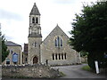
Holt U.R. Church
The church was opened in about 1816 as an Independent chapel. Worshippers were thought to have met in the assembly room next to the old White Hart before this was built. Extended in 1846, it became a Congregational Church by 1859. Later in the 19th century the rather typical Georgian nonconformist chapel was replaced by another building in the shape of a more conventional mainstream church. It was designed by William Jervis Stent (1815-1887) in a Victorian gothic style with an apse, a tower capped with a spire, and built of Atworth stone by John Ponton of Warminster. When the Congregationalists and the Presbyterians merged in 1972 it took the name United Reformed Church.
A benchmark can be seen on the church corner - see Image
Image: © Neil Owen
Taken: 16 Aug 2021
0.01 miles
4
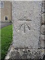
Benchmark on the U.R. church
A cutmark, as listed in the Benchmark Database: https://www.bench-marks.org.uk/bm66511 , on the corner of the church in Holt. See Image] for a wider view.
Image: © Neil Owen
Taken: 16 Aug 2021
0.01 miles
5
![Holt houses [14]](https://s1.geograph.org.uk/geophotos/06/41/42/6414237_26a1b0e0_120x120.jpg)
Holt houses [14]
Rose Cottage, number 366 The Street, is mid 19th century. The cottage has some fine railings attached. Listed, grade II, with details at: https://historicengland.org.uk/listing/the-list/list-entry/1021816
Two miles north east of Bradford-on-Avon the village of Holt originally consisted of a settlement around the church and an area around a triangular green called The Ham. The village greatly expanded in the later 20th century. Primarily an agricultural village, it was briefly a spa and there was a woollen cloth mill and factories producing leather, gloves and beds. Now a commuter village with workers travelling to Melksham, Trowbridge and Bradford-on-Avon.
Image: © Michael Dibb
Taken: 7 Mar 2020
0.01 miles

7

Entrance gates to Holt recreation ground
Attached to a pier is a plaque, bearing a legend regarding the fallen of the wars. See Image
Image: © Neil Owen
Taken: 16 Aug 2021
0.02 miles
8

A thank offering
A plaque on the recreation ground gates records a somewhat oddly-phrased tribute to the war losses. See Image] for a wider view.
Image: © Neil Owen
Taken: 16 Aug 2021
0.02 miles
9
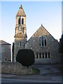
United Reformed church, Holt
A view looking south across the B3016 to the United Reformed church at Holt.
Image: © Phil Williams
Taken: 3 Mar 2006
0.02 miles
10
![Holt buildings [17]](https://s3.geograph.org.uk/geophotos/06/41/42/6414231_f33a037a_120x120.jpg)
Holt buildings [17]
This former Congregational chapel is adjacent to the church built, in 1880, to replace it Image Built circa 1810 and enlarged in 1846, the chapel was used as a school until the 1950s. The building was renovated in 1978 and it is now used as a church hall. Listed, grade II, with details at: https://historicengland.org.uk/listing/the-list/list-entry/1285623
Two miles north east of Bradford-on-Avon the village of Holt originally consisted of a settlement around the church and an area around a triangular green called The Ham. The village greatly expanded in the later 20th century. Primarily an agricultural village, it was briefly a spa and there was a woollen cloth mill and factories producing leather, gloves and beds. Now a commuter village with workers travelling to Melksham, Trowbridge and Bradford-on-Avon.
Image: © Michael Dibb
Taken: 7 Mar 2020
0.02 miles