IMAGES TAKEN NEAR TO
Bradley Lane, TROWBRIDGE, BA14 6QE
Introduction
This page details the photographs taken nearby to Bradley Lane, BA14 6QE by members of the Geograph project.
The Geograph project started in 2005 with the aim of publishing, organising and preserving representative images for every square kilometre of Great Britain, Ireland and the Isle of Man.

There are currently over 7.5m images from over14,400 individuals and you can help contribute to the project by visiting https://www.geograph.org.uk
Image Map
Images are licensed for reuse under creativecommons.org/licenses/by-sa/2.0
Notes
- Clicking on the map will re-center to the selected point.
- The higher the marker number, the further away the image location is from the centre of the postcode.
Image Listing (24 Images Found)
Images are licensed for reuse under creativecommons.org/licenses/by-sa/2.0
Image
Details
Distance
1
![Holt houses [8]](https://s2.geograph.org.uk/geophotos/06/41/32/6413238_4245d343_120x120.jpg)
Holt houses [8]
Springfield is a substantial detached house in Bradley Lane.
Two miles north east of Bradford-on-Avon the village of Holt originally consisted of a settlement around the church and an area around a triangular green called The Ham. The village greatly expanded in the later 20th century. Primarily an agricultural village, it was briefly a spa and there was a woollen cloth mill and factories producing leather, gloves and beds. Now a commuter village with workers travelling to Melksham, Trowbridge and Bradford-on-Avon.
Image: © Michael Dibb
Taken: 7 Mar 2020
0.07 miles
2
![Holt buildings [12]](https://s1.geograph.org.uk/geophotos/06/41/26/6412605_23809595_120x120.jpg)
Holt buildings [12]
Holt V C Primary School in The Gravel.
Two miles north east of Bradford-on-Avon the village of Holt originally consisted of a settlement around the church and an area around a triangular green called The Ham. The village greatly expanded in the later 20th century. Primarily an agricultural village, it was briefly a spa and there was a woollen cloth mill and factories producing leather, gloves and beds. Now a commuter village with workers travelling to Melksham, Trowbridge and Bradford-on-Avon.
Image: © Michael Dibb
Taken: 7 Mar 2020
0.10 miles
3
![Holt houses [9]](https://s3.geograph.org.uk/geophotos/06/41/32/6413239_44c1e4cc_120x120.jpg)
Holt houses [9]
The Retreat is a substantial detached house in Bradley Lane.
Two miles north east of Bradford-on-Avon the village of Holt originally consisted of a settlement around the church and an area around a triangular green called The Ham. The village greatly expanded in the later 20th century. Primarily an agricultural village, it was briefly a spa and there was a woollen cloth mill and factories producing leather, gloves and beds. Now a commuter village with workers travelling to Melksham, Trowbridge and Bradford-on-Avon.
Image: © Michael Dibb
Taken: 7 Mar 2020
0.10 miles
4

Holt primary school
A modern school which is part of the post-war expansion of Holt.
Image: © Neil Owen
Taken: 16 Aug 2021
0.11 miles
5
![Holt houses [7]](https://s1.geograph.org.uk/geophotos/06/41/32/6413237_d9618b65_120x120.jpg)
Holt houses [7]
The attractive Berry Cottage in Bradley Lane. The house is 16th century to the left with timber framing and a thatched roof. Under the stone slate roof to the right it is 17th century. Many original internal features survive. Listed, grade II, with details at: https://historicengland.org.uk/listing/the-list/list-entry/1194302
Two miles north east of Bradford-on-Avon the village of Holt originally consisted of a settlement around the church and an area around a triangular green called The Ham. The village greatly expanded in the later 20th century. Primarily an agricultural village, it was briefly a spa and there was a woollen cloth mill and factories producing leather, gloves and beds. Now a commuter village with workers travelling to Melksham, Trowbridge and Bradford-on-Avon.
Image: © Michael Dibb
Taken: 7 Mar 2020
0.12 miles
6

2007 : Holt Post Office
At this point the main road through Holt is called "The Common", to the left, at the centre of Holt it is called "The Street" and to the right, at the end of the village it becomes "Melksham Road", which would suggest this area was once common land.
Image: © Maurice Pullin
Taken: 16 Nov 2007
0.13 miles
7
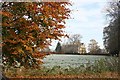
2007 : Autumn view from Station Road, Holt
Will enter information about the big house when I can find it.
Image: © Maurice Pullin
Taken: 16 Nov 2007
0.13 miles
9
![Holt houses [6]](https://s2.geograph.org.uk/geophotos/06/41/25/6412590_7486de34_120x120.jpg)
Holt houses [6]
Pickwick Cottage, number 272 The Gravel, is early 18th century and is said to have some original internal features. Listed, grade II, with details at: https://historicengland.org.uk/listing/the-list/list-entry/1285722
Two miles north east of Bradford-on-Avon the village of Holt originally consisted of a settlement around the church and an area around a triangular green called The Ham. The village greatly expanded in the later 20th century. Primarily an agricultural village, it was briefly a spa and there was a woollen cloth mill and factories producing leather, gloves and beds. Now a commuter village with workers travelling to Melksham, Trowbridge and Bradford-on-Avon.
Image: © Michael Dibb
Taken: 7 Mar 2020
0.14 miles
10
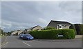
The Gravel
A road leading to the primary school.
Image: © Neil Owen
Taken: 16 Aug 2021
0.15 miles