IMAGES TAKEN NEAR TO
Staverton Road, TROWBRIDGE, BA14 6PL
Introduction
This page details the photographs taken nearby to Staverton Road, BA14 6PL by members of the Geograph project.
The Geograph project started in 2005 with the aim of publishing, organising and preserving representative images for every square kilometre of Great Britain, Ireland and the Isle of Man.

There are currently over 7.5m images from over14,400 individuals and you can help contribute to the project by visiting https://www.geograph.org.uk
Image Map
Images are licensed for reuse under creativecommons.org/licenses/by-sa/2.0
Notes
- Clicking on the map will re-center to the selected point.
- The higher the marker number, the further away the image location is from the centre of the postcode.
Image Listing (98 Images Found)
Images are licensed for reuse under creativecommons.org/licenses/by-sa/2.0
Image
Details
Distance
1
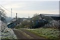
2007 : Manor Farm, Holt
Considering its size and location Manor Farm is very well hidden.
Image: © Maurice Pullin
Taken: 16 Nov 2007
0.02 miles
2
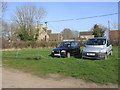
Overflow car park for the Courts garden, Holt
The Courts has become more popular than it was a few years ago. This March day was the first occasion in many visits where I was unable to find a space in the main car park and had to use the overflow one in this field.
[2019 update: for the last couple of years this field has been reserved for coaches. The overflow car park for cars visiting The Courts now is over the road near the Glove Factory studios.]
Image: © HelenK
Taken: 11 Mar 2012
0.05 miles
3
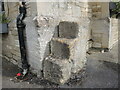
Corner steps on the Tollgate Inn
At the corner of the inn are some rough stone steps - presumably an aid to mounting horses in the past. Also close by is a benchmark beside the drain pipe. See https://www.bench-marks.org.uk/bm71703 for the entry in the Benchmark Database and Image] for a wider view.
Image: © Neil Owen
Taken: 16 Aug 2021
0.09 miles
4
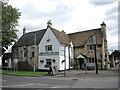
The Tollgate Inn
Standing at the edge of Ham Green is the old inn. It was known as the White Hart until a major refurbishment in 1980. Looking at the flight of steps to an upper floor to the left of shot, the building may have been used as a village assembly room in the past. See Image] for a benchmark on the corner.
Image: © Neil Owen
Taken: 16 Aug 2021
0.09 miles
5
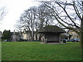
Ham Green, Holt
A view looking northwest across Ham Green, Holt showing the war memorial and rustic shelter.
Image: © Phil Williams
Taken: 17 Jan 2006
0.09 miles
6
![Holt buildings [20]](https://s2.geograph.org.uk/geophotos/06/41/59/6415954_77feb496_120x120.jpg)
Holt buildings [20]
The Tollgate Inn was formerly the White Hart Inn, renamed following refurbishment circa 1980. The building incorporates what was probably the village meeting room built in the mid 18th century with the external stone steps to the left. The main part of the inn is early 20th century. Listed, grade II, with details at: https://historicengland.org.uk/listing/the-list/list-entry/1021803
Two miles north east of Bradford-on-Avon the village of Holt originally consisted of a settlement around the church and an area around a triangular green called The Ham. The village greatly expanded in the later 20th century. Primarily an agricultural village, it was briefly a spa and there was a woollen cloth mill and factories producing leather, gloves and beds. Now a commuter village with workers travelling to Melksham, Trowbridge and Bradford-on-Avon.
Image: © Michael Dibb
Taken: 7 Mar 2020
0.09 miles
7
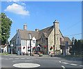
The Tollgate Inn
Previously known as the White Hart the English Heritage Building ID: 314497
cites a Grade II listed building dating from the 18th C. The pub's website subtracts two centuries from this.
Image: © Stuart Logan
Taken: 24 Jul 2014
0.09 miles
9
Old assembly rooms?
This building adjoining what was once the White Hart Inn (now the Tollgate) may have been used as a village assembly room. It has a curious exterior flight of steps and some very specific wall ties holding it all together.
Image: © Neil Owen
Taken: 16 Aug 2021
0.09 miles
10
![Holt houses [32]](https://s1.geograph.org.uk/geophotos/06/41/59/6415949_87de5411_120x120.jpg)
Holt houses [32]
Devon Cottage, numer 16 Leigh Road, is an early 19th century cottage in a row. Listed, grade II, with details at: https://historicengland.org.uk/listing/the-list/list-entry/1021809 The adjacent property on th left, number 15 Leigh Road, has been incorporated as part of Holt House Image
Two miles north east of Bradford-on-Avon the village of Holt originally consisted of a settlement around the church and an area around a triangular green called The Ham. The village greatly expanded in the later 20th century. Primarily an agricultural village, it was briefly a spa and there was a woollen cloth mill and factories producing leather, gloves and beds. Now a commuter village with workers travelling to Melksham, Trowbridge and Bradford-on-Avon.
Image: © Michael Dibb
Taken: 7 Mar 2020
0.10 miles