IMAGES TAKEN NEAR TO
Hilperton Drive, TROWBRIDGE, BA14 6JA
Introduction
This page details the photographs taken nearby to Hilperton Drive, BA14 6JA by members of the Geograph project.
The Geograph project started in 2005 with the aim of publishing, organising and preserving representative images for every square kilometre of Great Britain, Ireland and the Isle of Man.

There are currently over 7.5m images from over14,400 individuals and you can help contribute to the project by visiting https://www.geograph.org.uk
Image Map
Images are licensed for reuse under creativecommons.org/licenses/by-sa/2.0
Notes
- Clicking on the map will re-center to the selected point.
- The higher the marker number, the further away the image location is from the centre of the postcode.
Image Listing (4 Images Found)
Images are licensed for reuse under creativecommons.org/licenses/by-sa/2.0
Image
Details
Distance
1
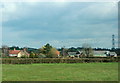
2008 : Lower Paxcroft Farm
Mostly dairy.
Near the eastern end of the Hilperton bypass.
Image: © Maurice Pullin
Taken: 11 Apr 2008
0.02 miles
2
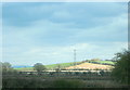
2008 : Fields near Lower Paxcroft
With Hag Hill in the background.
A fairly new housing estate lurks behind the camera.
Image: © Maurice Pullin
Taken: 11 Apr 2008
0.08 miles
3
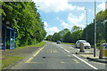
Bus stop on A361 Hilperton Drive
An example of the prevention of overtaking of a stopped bus, as practised by some highway authorities in appropriate locations.
Image: © Robin Webster
Taken: 30 May 2021
0.23 miles
4
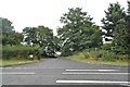
The entrance to Lower Paxcroft Farm, Hilperton
Image: © David Howard
Taken: 21 Aug 2016
0.23 miles