IMAGES TAKEN NEAR TO
Holt, TROWBRIDGE, BA14 6FW
Introduction
This page details the photographs taken nearby to BA14 6FW by members of the Geograph project.
The Geograph project started in 2005 with the aim of publishing, organising and preserving representative images for every square kilometre of Great Britain, Ireland and the Isle of Man.

There are currently over 7.5m images from over14,400 individuals and you can help contribute to the project by visiting https://www.geograph.org.uk
Image Map
Images are licensed for reuse under creativecommons.org/licenses/by-sa/2.0
Notes
- Clicking on the map will re-center to the selected point.
- The higher the marker number, the further away the image location is from the centre of the postcode.
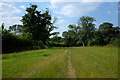
Image Listing (5 Images Found)
Images are licensed for reuse under creativecommons.org/licenses/by-sa/2.0
Image
Details
Distance
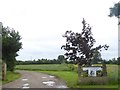
1
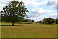
Field north of Holt
Crossed by the path between Holt and Great Chalfield.
Image: © David Martin
Taken: 1 Aug 2018
0.13 miles
3
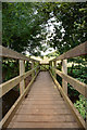
Footpath to Great Chalfield Manor
This footpath runs between The Midlands (Holt) and Great Chalfield Manor
Image: © Doug Lee
Taken: 7 Jul 2013
0.20 miles
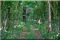
4
Gateway for Copse Farm
There is a footpath to Holt on the right of this field
Image: © David Smith
Taken: 8 Jun 2017
0.24 miles