IMAGES TAKEN NEAR TO
Church View, TROWBRIDGE, BA14 6EJ
Introduction
This page details the photographs taken nearby to Church View, BA14 6EJ by members of the Geograph project.
The Geograph project started in 2005 with the aim of publishing, organising and preserving representative images for every square kilometre of Great Britain, Ireland and the Isle of Man.

There are currently over 7.5m images from over14,400 individuals and you can help contribute to the project by visiting https://www.geograph.org.uk
Image Map
Images are licensed for reuse under creativecommons.org/licenses/by-sa/2.0
Notes
- Clicking on the map will re-center to the selected point.
- The higher the marker number, the further away the image location is from the centre of the postcode.
Image Listing (235 Images Found)
Images are licensed for reuse under creativecommons.org/licenses/by-sa/2.0
Image
Details
Distance
1
![Steeple Ashton houses [19]](https://s1.geograph.org.uk/geophotos/07/43/38/7433869_403df244_120x120.jpg)
Steeple Ashton houses [19]
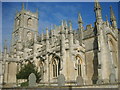
Bartletts Farmhouse was built in the mid 18th century. Constructed of brick with freestone dressings under a Bridgwater tile roof. The left gable end is dressed limestone. There is a later slate-hung wing to the right rear. Listed, grade II, with details at: https://historicengland.org.uk/listing/the-list/list-entry/1252515
The village of Steeple Ashton is a former market town, having been granted a weekly market in 1266. It lies some 3¼ miles east of Trowbridge and some 7 miles southwest of Devizes. The town became wealthy from its cloth industry, but there was a great fire in the early 16th century, and when it came to rebuilding the industry moved to the nearby town of Trowbridge, where the River Biss provided power for fulling mills. The first part of the village name comes from the former church spire, which collapsed in 1670.
Image: © Michael Dibb
Taken: 14 Feb 2023
0.04 miles
2

Footpath, Steeple Ashton
A narrow footpath runs along the church wall. It takes walkers along the back of the village houses.
Image: © Maigheach-gheal
Taken: 27 Jul 2009
0.04 miles
3
![Steeple Ashton houses [22]](https://s3.geograph.org.uk/geophotos/07/43/44/7434423_add6acf2_120x120.jpg)
Steeple Ashton houses [22]
Number 12 High Street is a detached cottage built circa 1600. Timber framed with square panels and brick nogging on a rubble stone plinth under a Bridgwater tile roof. The left return was rebuilt in the 19th century in limestone and brick random chequers. There are two rear lean-to extensions. Listed, grade II, with details at: https://historicengland.org.uk/listing/the-list/list-entry/1262242
The village of Steeple Ashton is a former market town, having been granted a weekly market in 1266. It lies some 3¼ miles east of Trowbridge and some 7 miles southwest of Devizes. The town became wealthy from its cloth industry, but there was a great fire in the early 16th century, and when it came to rebuilding the industry moved to the nearby town of Trowbridge, where the River Biss provided power for fulling mills. The first part of the village name comes from the former church spire, which collapsed in 1670.
Image: © Michael Dibb
Taken: 14 Feb 2023
0.05 miles
4
![Steeple Ashton houses [17]](https://s1.geograph.org.uk/geophotos/07/43/38/7433857_b1209bab_120x120.jpg)
Steeple Ashton houses [17]
Church Farmhouse, number 5 High Street, was built in the mid 16th century and extended in the mid and late 17th century. Timber framed with square panels and brick nogging, partly pebbledashed, under a stone slate roof. The front gable end of the 16th century wing was originally jettied, and altered in the 19th century. Some original internal features remain. Listed, grade II, with details at: https://historicengland.org.uk/listing/the-list/list-entry/1262237
The village of Steeple Ashton is a former market town, having been granted a weekly market in 1266. It lies some 3¼ miles east of Trowbridge and some 7 miles southwest of Devizes. The town became wealthy from its cloth industry, but there was a great fire in the early 16th century, and when it came to rebuilding the industry moved to the nearby town of Trowbridge, where the River Biss provided power for fulling mills. The first part of the village name comes from the former church spire, which collapsed in 1670.
Image: © Michael Dibb
Taken: 14 Feb 2023
0.06 miles
6
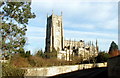
St Mary's Church, Steeple Aston
Taken from the driveway of a house opposite.
Image: © William Metcalfe
Taken: 22 Sep 2007
0.06 miles
7
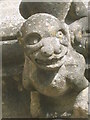
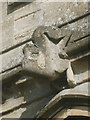
Grotesque on St Mary's Church
One of several on the south side of the church.
Image: © William Metcalfe
Taken: 22 Sep 2007
0.06 miles
8
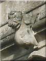
Grotesque at St Mary's Church
Apparently recently restored, I have classed it as a gargoyle even though it has no drainage function. There are several on the wall of this church.
Image: © William Metcalfe
Taken: 22 Sep 2007
0.06 miles
9
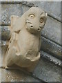
Steeple Ashton grotesque
One of several figures on the side of St Mary's Church.
Image: © William Metcalfe
Taken: 22 Sep 2007
0.06 miles
10
St Mary's Church grotesque
One of several grotesque animals on the outside of the church.
Image: © William Metcalfe
Taken: 22 Sep 2007
0.06 miles