IMAGES TAKEN NEAR TO
West Ashton, TROWBRIDGE, BA14 6DF
Introduction
This page details the photographs taken nearby to BA14 6DF by members of the Geograph project.
The Geograph project started in 2005 with the aim of publishing, organising and preserving representative images for every square kilometre of Great Britain, Ireland and the Isle of Man.

There are currently over 7.5m images from over14,400 individuals and you can help contribute to the project by visiting https://www.geograph.org.uk
Image Map
Images are licensed for reuse under creativecommons.org/licenses/by-sa/2.0
Notes
- Clicking on the map will re-center to the selected point.
- The higher the marker number, the further away the image location is from the centre of the postcode.
Image Listing (3 Images Found)
Images are licensed for reuse under creativecommons.org/licenses/by-sa/2.0
Image
Details
Distance
1

Warp Speed!!
The Temporal Highway Patrol in pursuit of Doc Brown as he tests a newly installed flux capacitor along the A350 at Armouracre Farm.
Sorry, couldn't resist it!
Image: © Phil Williams
Taken: 16 Dec 2005
0.03 miles
2
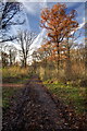
Path in Green Lane Wood
Green Lane Wood is owned and managed by the Wiltshire Wildlife Trust. This is the main track into the wood from the car park on the A350.
Image: © Doug Lee
Taken: 29 Nov 2012
0.08 miles
3
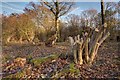
Recently Coppiced Trees in Green Lane Wood
Green Lane Wood is owned and managed by the Wiltshire Wildlife Trust. Coppicing is carried out each winter by volunteers.
Image: © Doug Lee
Taken: 29 Nov 2012
0.13 miles