IMAGES TAKEN NEAR TO
Orchard Close, TROWBRIDGE, BA14 6AU
Introduction
This page details the photographs taken nearby to Orchard Close, BA14 6AU by members of the Geograph project.
The Geograph project started in 2005 with the aim of publishing, organising and preserving representative images for every square kilometre of Great Britain, Ireland and the Isle of Man.

There are currently over 7.5m images from over14,400 individuals and you can help contribute to the project by visiting https://www.geograph.org.uk
Image Map
Images are licensed for reuse under creativecommons.org/licenses/by-sa/2.0
Notes
- Clicking on the map will re-center to the selected point.
- The higher the marker number, the further away the image location is from the centre of the postcode.
Image Listing (17 Images Found)
Images are licensed for reuse under creativecommons.org/licenses/by-sa/2.0
Image
Details
Distance
1

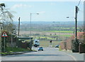
West Ashton crossroads
A view of the A350 (running left to right) where the minor road from Trowbridge to Bratton crosses it at a traffic light controlled junction. The gateposts below the trees at left of centre mark the entrance drive to Rood Ashton Hall which dates from 1808. However, most of the hall was demolished in the late 70's, leaving one part remaining as a private residence.
The name is also preserved on the GWR Hall class steam locomotive '4965'which is still in use for railtours.
Image: © Phil Williams
Taken: 16 Sep 2005
0.04 miles
2
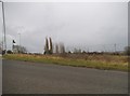
2008 : West Ashton crossroads (2)
Image] gives the view from the opposite direction with interesting information.
In this photo Trowbridge can be seen in the distance.
Image: © Maurice Pullin
Taken: 11 Apr 2008
0.05 miles

5

Old Milestone by the A350, Yarnbrook Road, West Ashton
Stone post (plate lost) by the A350, in parish of WEST ASHTON (WEST WILTSHIRE District), Yarnbrook Road; West Ashton; 200m South of crossroads/traffic lights, on the verge, on East side of road. Westbury plate, erected by the Westbury turnpike trust in the 19th century.
Inscription once read:-
(Westbury)
(3)
(Melksham)
(5½)
Carved benchmark right middle.
Milestone Society National ID: WI_WYMK03.
Image: © M Faherty
Taken: 4 Nov 2007
0.09 miles
6

Old Milestone by the A350, Yarnbrook Road, West Ashton
Stone post (plate lost) by the A350, in parish of WEST ASHTON (WEST WILTSHIRE District), Yarnbrook Road; West Ashton; 200m South of crossroads/traffic lights, on the verge, on East side of road. Westbury plate, erected by the Westbury turnpike trust in the 19th century.
Inscription once read:-
(Westbury)
(3)
(Melksham)
(5½)
Carved benchmark right middle.
Milestone Society National ID: WI_WYMK03.
Image: © Gail Fawcett
Taken: 27 Dec 2023
0.09 miles
7
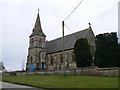
St John The Evangelist, West Ashton
Church at West Ashton
Image: © Colin Madge
Taken: 28 Feb 2009
0.12 miles
8
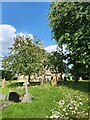
A midsummer visit to St John the Evangelist, West Ashton (1)
Image: © Basher Eyre
Taken: 26 Jun 2024
0.16 miles
9
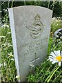
A midsummer visit to St John the Evangelist, West Ashton (8)
For Foot's service record see https://www.cwgc.org/find-records/find-war-dead/casualty-details/2710514/henry-george-foot/
Image: © Basher Eyre
Taken: 26 Jun 2024
0.16 miles
10
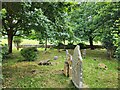
A midsummer visit to St John the Evangelist, West Ashton (7)
Image: © Basher Eyre
Taken: 26 Jun 2024
0.16 miles