IMAGES TAKEN NEAR TO
Ashton Heights, TROWBRIDGE, BA14 6AL
Introduction
This page details the photographs taken nearby to Ashton Heights, BA14 6AL by members of the Geograph project.
The Geograph project started in 2005 with the aim of publishing, organising and preserving representative images for every square kilometre of Great Britain, Ireland and the Isle of Man.

There are currently over 7.5m images from over14,400 individuals and you can help contribute to the project by visiting https://www.geograph.org.uk
Image Map
Images are licensed for reuse under creativecommons.org/licenses/by-sa/2.0
Notes
- Clicking on the map will re-center to the selected point.
- The higher the marker number, the further away the image location is from the centre of the postcode.
Image Listing (4 Images Found)
Images are licensed for reuse under creativecommons.org/licenses/by-sa/2.0
Image
Details
Distance
1
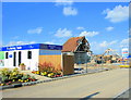
2008 : The old and the new
I rather liked the idea of the brand sparkling new site office turning its back on the half demolished barn. Bearing in mind the site office will also go when the houses have been built.
Ashes to ashes, dust to dust, if the dry rot don't get us the developers must.
Image: © Maurice Pullin
Taken: 11 Apr 2008
0.14 miles
2
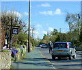
2008 : 25 Bratton Road, West Ashton
Was the house number displayed like this to fool motorists into slowing down? If it was, more power to you sir, or madam, pity you don't live in number 20.
They see him here they see him there, that white horse Image
pops up everywhere. Did you spot him at the end of the road?
Image: © Maurice Pullin
Taken: 11 Apr 2008
0.15 miles
3
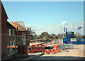
2008 : Building site, West Ashton
Not easy to make a building site look pretty. Bring in a few flags and some bright colours, get the clouds to co-operate, it can be done.
The finished houses are a great improvement on the utilitarian but dull stuff that was being built in the 1960/70 era.
Image: © Maurice Pullin
Taken: 11 Apr 2008
0.16 miles
4
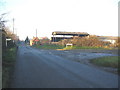
East Town Road
Looking northwest along Bratton Road at West Ahston, at the junction with East Town Road.
Image: © Phil Williams
Taken: 11 Dec 2005
0.22 miles