IMAGES TAKEN NEAR TO
Yarnbrook, TROWBRIDGE, BA14 6AB
Introduction
This page details the photographs taken nearby to BA14 6AB by members of the Geograph project.
The Geograph project started in 2005 with the aim of publishing, organising and preserving representative images for every square kilometre of Great Britain, Ireland and the Isle of Man.

There are currently over 7.5m images from over14,400 individuals and you can help contribute to the project by visiting https://www.geograph.org.uk
Image Map
Images are licensed for reuse under creativecommons.org/licenses/by-sa/2.0
Notes
- Clicking on the map will re-center to the selected point.
- The higher the marker number, the further away the image location is from the centre of the postcode.
Image Listing (14 Images Found)
Images are licensed for reuse under creativecommons.org/licenses/by-sa/2.0
Image
Details
Distance
1

Passenger Train at Yarnbrook
Passenger train passing the lake near Yarnbrook.
Image: © Wayland Smith
Taken: 29 Apr 2007
0.05 miles
2
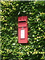
Yarnbrook: postbox № BA14 12
A standard Elizabeth II-reign lamp box poking out of a hedge on the main road just north of the main junction in the village. It has final collection times of noon on weekdays and 10:30am on Saturdays, but there are later collections available from the box a short distance away, on the garage forecourt - see Image
Image: © Chris Downer
Taken: 30 Jun 2014
0.09 miles
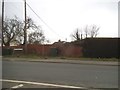
4

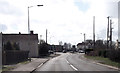
A363 Westbury Road, North Bradley
Towards Trowbridge.
Image: © Robin Webster
Taken: 30 May 2021
0.14 miles
5

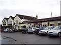
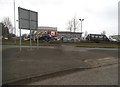
Yarnbrook: postbox № BA14 84
This postbox is of a modern but fairly uncommon design and seems to appear predominantly on filling station forecourts, as is indeed the case here. It has final collection times of 4:30pm on weekdays and noon on Saturday - considerably later than the more standard box which remains in service just up the road: see Image
Image: © Chris Downer
Taken: 30 Jun 2014
0.16 miles
6
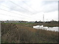
Meridian Motor Park, Trowbridge
Looking east across a catchment pond installed as part of the Heywood Link road scheme. The Meridian Motor Park can be seen at centre left, with the embankment carrying the Bristol-Portsmouth rail line is at centre right. The teazels in the left foreground were once an important part of the local economy, as they had a use in the woollen industry , which was formerly significant in this part of Wiltshire.
Image: © Phil Williams
Taken: 27 Nov 2005
0.16 miles
9

Yarnbrook Roundabout
Looking northwest along the A350 to the roundabout at Yarnbrook. The A350 turns right at this roundabout, with the straight ahead road being the A363. The road to the left provides access to the West Wilts Trading Estate. This roundabout can get very congested at peak times with extensive queues developing on the A350.
Image: © Phil Williams
Taken: 11 Dec 2005
0.17 miles