IMAGES TAKEN NEAR TO
Broadley Park, TROWBRIDGE, BA14 0SS
Introduction
This page details the photographs taken nearby to Broadley Park, BA14 0SS by members of the Geograph project.
The Geograph project started in 2005 with the aim of publishing, organising and preserving representative images for every square kilometre of Great Britain, Ireland and the Isle of Man.

There are currently over 7.5m images from over14,400 individuals and you can help contribute to the project by visiting https://www.geograph.org.uk
Image Map
Images are licensed for reuse under creativecommons.org/licenses/by-sa/2.0
Notes
- Clicking on the map will re-center to the selected point.
- The higher the marker number, the further away the image location is from the centre of the postcode.
Image Listing (42 Images Found)
Images are licensed for reuse under creativecommons.org/licenses/by-sa/2.0
Image
Details
Distance
1
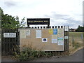
Notice board on the entrance to the Peace Memorial grounds
Plenty to read: some warning notices, some activity adverts and, in the middle, is a letter from the Queen regarding the Jubilee Lunches events.
Image: © Neil Owen
Taken: 4 Aug 2022
0.09 miles
2

North Bradley village pound
A small enclosure on the Southwick Road has been retained as a historical feature. When farm livestock escaped they were rounded up and kept in this pound before their owners returned.
Whilst the pound is no longer in use it has a concrete information display, showing a map of the parish area which includes the churches and pubs.
Image: © Neil Owen
Taken: 4 Aug 2022
0.10 miles
3
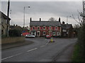
The Rising Sun, North Bradley
Looking northwest along the A361 to the mini-roundabout outside the Rising Sun public house. The A361 takes a sharp left turn at this point and continues west towards Southwick.
Image: © Phil Williams
Taken: 27 Nov 2005
0.11 miles
4
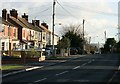
2007 : Woodmarsh, North Bradley
The mini- roundabout at the junction of the road to Southwick is just about as far as you can see along here.
The Westbury white horse Image appears in the distance.
Image: © Maurice Pullin
Taken: 29 Nov 2007
0.11 miles
5

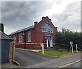
Peace Memorial hall and playing field
The main hall and part of the playing fields, located on the Southwick Road. See Image] for a plaque.
Image: © Neil Owen
Taken: 4 Aug 2022
0.12 miles
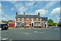
7
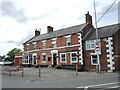
The Rising Sun. North Bradley
Standing at the junction of Woodmarsh, Westbury Road and Southwick Road, the pub has been here for well over a century. Back then it had only a few cottages for neighbours.
Image: © Neil Owen
Taken: 4 Aug 2022
0.13 miles
8
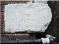
Benchmark on the Rising Sun
A cutmark of twentieth century vintage on the side of the pub. See https://www.bench-marks.org.uk/bm105347 for the entry in the Benchmark Database and Image] for a wider view.
Image: © Neil Owen
Taken: 4 Aug 2022
0.13 miles
9
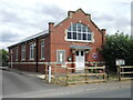
North Bradley Progressive Hall
The hall was a publicly-funded venture, benefiting from a gift of the land by a Mr Hancock. A committee was charged with its management from the opening in 1912.
Image: © Neil Owen
Taken: 4 Aug 2022
0.13 miles
10
North Bradley Progressive Hall
The North Bradley Progressive Hall was built with funds donated by Villagers on land gifted by a Mr Hancock. The land and Building were then conveyed to Trustees and opened for public use in September 1912. The Trustees were charged with the management and care of the Hall for public use and private entertainment subject to such rules and regulations that the Trustees lay down. The Hall has been in continuous use since its opening until the present day
Image: © Anthony Parkes
Taken: 27 Jul 2021
0.13 miles