
IMAGES TAKEN NEAR TO
Elm Close, TROWBRIDGE, BA14 0SF
Introduction
This page details the photographs taken nearby to Elm Close, BA14 0SF by members of the Geograph project.
The Geograph project started in 2005 with the aim of publishing, organising and preserving representative images for every square kilometre of Great Britain, Ireland and the Isle of Man.

There are currently over 7.5m images from over14,400 individuals and you can help contribute to the project by visiting https://www.geograph.org.uk
Image Map
Images are licensed for reuse under creativecommons.org/licenses/by-sa/2.0
Notes
- Clicking on the map will re-center to the selected point.
- The higher the marker number, the further away the image location is from the centre of the postcode.
Image Listing (51 Images Found)
Images are licensed for reuse under creativecommons.org/licenses/by-sa/2.0
Image
Details
Distance
1

North Bradley village pound
A small enclosure on the Southwick Road has been retained as a historical feature. When farm livestock escaped they were rounded up and kept in this pound before their owners returned.
Whilst the pound is no longer in use it has a concrete information display, showing a map of the parish area which includes the churches and pubs.
Image: © Neil Owen
Taken: 4 Aug 2022
0.05 miles
2
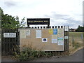
Notice board on the entrance to the Peace Memorial grounds
Plenty to read: some warning notices, some activity adverts and, in the middle, is a letter from the Queen regarding the Jubilee Lunches events.
Image: © Neil Owen
Taken: 4 Aug 2022
0.05 miles
3

Peace Memorial hall and playing field
The main hall and part of the playing fields, located on the Southwick Road. See Image] for a plaque.
Image: © Neil Owen
Taken: 4 Aug 2022
0.07 miles
4

Peace Hall plaque
Along with some important kit and flowers, the hall bears this plaque. It relates how the trust was founded in 1944 for returning servicemen, with the hall and fields created in 1951.
Image: © Neil Owen
Taken: 4 Aug 2022
0.08 miles
5
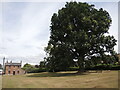
Royal connections on Southwick Road
The smallish patch of green still remaining in North Bradley is a pleasant open space with some historic trees. The large specimen was planted in 1897 to mark Queen Victoria's Diamond Jubilee; the smaller one behind it was planted to commemorate the coronation of Queen Elizabeth II in 1953.
Beyond is a cottage that was once the post office, and beyond again (out of shot) were the two pubs, named the Old Ring of Bells Inn and the other the New Ring of Bells Inn. Both have been closed.
Image: © Neil Owen
Taken: 4 Aug 2022
0.09 miles
7
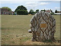
A celebratory seat
A large carved wooden seat stands in the Peace Memorial playing fields as the lines are being marked; it is dedicated to a local woman who worked to improve the village. See Image] for a frontal view.
Image: © Neil Owen
Taken: 4 Aug 2022
0.14 miles
8
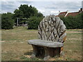
A carved celebration
An elaborately carved seat in the North Bradley Peace Memorial playing fields is dedicated to a local woman. Behind is a popular play area for the little ones. See Image] for the rear view.
Image: © Neil Owen
Taken: 4 Aug 2022
0.14 miles
10
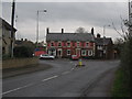
The Rising Sun, North Bradley
Looking northwest along the A361 to the mini-roundabout outside the Rising Sun public house. The A361 takes a sharp left turn at this point and continues west towards Southwick.
Image: © Phil Williams
Taken: 27 Nov 2005
0.15 miles