IMAGES TAKEN NEAR TO
Marston Road, TROWBRIDGE, BA14 0LP
Introduction
This page details the photographs taken nearby to Marston Road, BA14 0LP by members of the Geograph project.
The Geograph project started in 2005 with the aim of publishing, organising and preserving representative images for every square kilometre of Great Britain, Ireland and the Isle of Man.

There are currently over 7.5m images from over14,400 individuals and you can help contribute to the project by visiting https://www.geograph.org.uk
Image Map
Images are licensed for reuse under creativecommons.org/licenses/by-sa/2.0
Notes
- Clicking on the map will re-center to the selected point.
- The higher the marker number, the further away the image location is from the centre of the postcode.
Image Listing (6 Images Found)
Images are licensed for reuse under creativecommons.org/licenses/by-sa/2.0
Image
Details
Distance
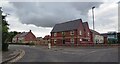
2
West Wiltshire District Council offices
Looking east across Bradley Road, Trowbridge to the offices of West Wiltshire District Council, situated at the junction with Wiltshire Drive.
Image: © Phil Williams
Taken: 18 Dec 2005
0.16 miles
3
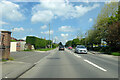
A363 Bradley Road, Trowbridge
Towards the town centre.
Image: © Robin Webster
Taken: 30 May 2021
0.19 miles
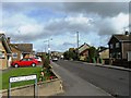
4
New Housing on Wiltshire Drive - Trowbridge
Image: © Anthony Parkes
Taken: 27 Jul 2021
0.19 miles
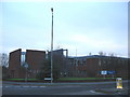
5
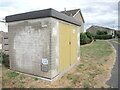
Gas installation on Marston Road
Marked as an electricity substation on the map, it is clearly a gas utility.
Image: © Neil Owen
Taken: 4 Aug 2022
0.21 miles
6

2007 : On Bradley Road, Trowbridge
Looking toward the roundabout at the Trowbridge end of the North Bradley bypass.
During WW2 a factory for assembling spitfires stood to the left of this road on a site now occupied by a DIY supermarket. http://www.aeroflight.co.uk/types/uk/supermarine/spitfireI-III/Spitfire1.htm
http://www.trowbridge.gov.uk/towninfo.asp?id=194
Image: © Maurice Pullin
Taken: 29 Nov 2007
0.24 miles