IMAGES TAKEN NEAR TO
Walnut Grove, TROWBRIDGE, BA14 0HR
Introduction
This page details the photographs taken nearby to Walnut Grove, BA14 0HR by members of the Geograph project.
The Geograph project started in 2005 with the aim of publishing, organising and preserving representative images for every square kilometre of Great Britain, Ireland and the Isle of Man.

There are currently over 7.5m images from over14,400 individuals and you can help contribute to the project by visiting https://www.geograph.org.uk
Image Map
Images are licensed for reuse under creativecommons.org/licenses/by-sa/2.0
Notes
- Clicking on the map will re-center to the selected point.
- The higher the marker number, the further away the image location is from the centre of the postcode.
Image Listing (6 Images Found)
Images are licensed for reuse under creativecommons.org/licenses/by-sa/2.0
Image
Details
Distance
1

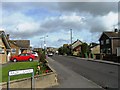
Two new houses, Chestnut Grove, Upper Studley
Image: © Alex McGregor
Taken: 22 Aug 2012
0.14 miles
2
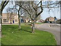
Trowbridge: College Road
Trowbridge College and Arc Theatre on the left
Image: © David Gearing
Taken: 9 Apr 2010
0.22 miles
3
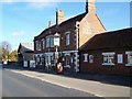
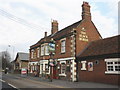
The Black Horse, Southwick
The inn is beside the A361, Frome Road.
Image: © Maigheach-gheal
Taken: 17 Nov 2009
0.23 miles
5

Trowbridge College
Looking northeast across College road to the main entrance to the Trowbridge College campus, part of the Wiltshire College.
Image: © Phil Williams
Taken: 18 Dec 2005
0.24 miles