IMAGES TAKEN NEAR TO
Upper Bristol Road, BA1 3ER
Introduction
This page details the photographs taken nearby to Upper Bristol Road, BA1 3ER by members of the Geograph project.
The Geograph project started in 2005 with the aim of publishing, organising and preserving representative images for every square kilometre of Great Britain, Ireland and the Isle of Man.

There are currently over 7.5m images from over14,400 individuals and you can help contribute to the project by visiting https://www.geograph.org.uk
Image Map
Images are licensed for reuse under creativecommons.org/licenses/by-sa/2.0
Notes
- Clicking on the map will re-center to the selected point.
- The higher the marker number, the further away the image location is from the centre of the postcode.
Image Listing (383 Images Found)
Images are licensed for reuse under creativecommons.org/licenses/by-sa/2.0
Image
Details
Distance
1
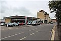
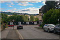
Hintons, Upper Bristol Road, Bath
Vauxhall Garage on the A4.
One of the few remaining garages capable of servicing LPG systems.
Image: © Bob Embleton
Taken: 8 Aug 2012
0.01 miles
2
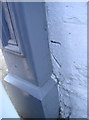
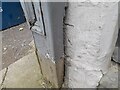
Almost covered
The corner of the building is listed as having a benchmark and this looks suspiciously like it, despite being largely covered by the office frontage. See Image] for a view of the actual buildings and http://www.bench-marks.org.uk/bm41416 for the entry in the Benchmark Database.
Image: © Neil Owen
Taken: 16 Jan 2012
0.02 miles
3
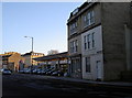
Albion Place and a Vauxhall garage
Along the Upper Bristol Road are a number of older buildings that survived the Blitz. For those that didn't new occupants have made themselves a living. On the corner of the left-hand of the taller buildings was a benchmark - see Image] for what might be the remainder.
Image: © Neil Owen
Taken: 16 Jan 2012
0.02 miles
4
Ordnance Survey Cut Mark
This OS cut mark can be found on No8 Albion Place. It marks a point 22.338m above mean sea level.
Image: © Adrian Dust
Taken: 3 Dec 2022
0.02 miles
5
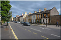
Bath : Upper Bristol Road A4
Looking along Upper Bristol Road.
Image: © Lewis Clarke
Taken: 6 Aug 2020
0.02 miles
6
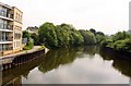
Panorama from Marlborough Lane #2
Looking south-southwest.
Image: © Robert Lamb
Taken: 31 Jul 2011
0.03 miles
7
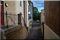
Bath : Alleyway
An alley between Upper Bristol Road and Nelson Place West.
Image: © Lewis Clarke
Taken: 6 Aug 2020
0.03 miles
8
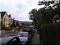
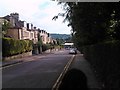
Bath : Marlborough Lane
Looking along Marlborough Lane approaching the junction with Upper Bristol Road.
Image: © Lewis Clarke
Taken: 6 Aug 2020
0.03 miles
9
Panorama from Marlborough Lane
Looking south-southwest. This and all following images were taken on my cameraphone, as both my camera batteries died at this point!
Image: © Robert Lamb
Taken: 31 Jul 2011
0.03 miles