IMAGES TAKEN NEAR TO
Upper Bristol Road, BATH, BA1 3DL
Introduction
This page details the photographs taken nearby to Upper Bristol Road, BA1 3DL by members of the Geograph project.
The Geograph project started in 2005 with the aim of publishing, organising and preserving representative images for every square kilometre of Great Britain, Ireland and the Isle of Man.

There are currently over 7.5m images from over14,400 individuals and you can help contribute to the project by visiting https://www.geograph.org.uk
Image Map
Images are licensed for reuse under creativecommons.org/licenses/by-sa/2.0
Notes
- Clicking on the map will re-center to the selected point.
- The higher the marker number, the further away the image location is from the centre of the postcode.
Image Listing (130 Images Found)
Images are licensed for reuse under creativecommons.org/licenses/by-sa/2.0
Image
Details
Distance
1
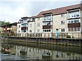
Flats off Upper Bristol Road, Bath
On the north bank of the River Avon.
Image: © Christine Johnstone
Taken: 3 May 2015
0.01 miles
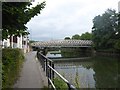
2
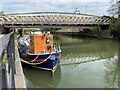
Barge on the Avon
Barge on the River Avon below Windsor Bridge, Bath.
Image: © Alan Hughes
Taken: 14 Apr 2021
0.02 miles
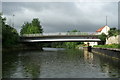
3
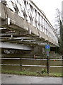
Windsor Bridge, pipelines
Windsor Bridge carries a lot of vehicular traffic over it, but a smaller bridge beside it carries several pipelines. Currently, the footpath/cyclepath has been blocked off as work is carried out under the bridges.
Image: © Neil Owen
Taken: 6 Jan 2012
0.03 miles
4

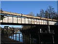
Windsor Bridge
Two bridges alongside each other over the River Avon. The road bridge seen alongside the old lattice bridge was constructed in 1980. The lattice bridge carries a footpath and pipelines.
Image: © Michael Dibb
Taken: 2 Jun 2018
0.03 miles
5
Old pipes over Windsor Road bridge
The pipes carried above the bridge may well be disused gas pipes as there are lots of newer ones installed below the deck level. See Image
Image: © Neil Owen
Taken: 20 Jan 2023
0.03 miles
6
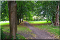
Bath : Footpath
A footpath heads towards Windsor Villas.
Image: © Lewis Clarke
Taken: 6 Aug 2020
0.04 miles
7
Windsor Bridge, River Avon, Bath
Road bridge linking Lower Weston and East Twerton, view downstream.
Image: © Pierre Terre
Taken: 20 May 2006
0.04 miles
8

River Avon below Windsor Bridge
Looking upstream to the footbridge side of the bridge, with Lansdown Image on the skyline.
Image: © Pierre Terre
Taken: 21 May 2006
0.04 miles
9

The River Avon
Looking downstream from the footpath on the north bank near Windsor Bridge. The bridge in the distance carried the Midland Railway's Mangotsfield and Bath Branch Line which closed to passengers in 1966 and to goods in 1971.
Image: © Michael Dibb
Taken: 2 Jun 2018
0.04 miles
10
Pipeline bridge over River Avon, East Twerton
This is adjacent to the Windsor road bridge carrying the A3604; there is a footpath with the pipelines
Image: © David Smith
Taken: 7 Jul 2016
0.04 miles