IMAGES TAKEN NEAR TO
Audley Grove, BATH, BA1 3BT
Introduction
This page details the photographs taken nearby to Audley Grove, BA1 3BT by members of the Geograph project.
The Geograph project started in 2005 with the aim of publishing, organising and preserving representative images for every square kilometre of Great Britain, Ireland and the Isle of Man.

There are currently over 7.5m images from over14,400 individuals and you can help contribute to the project by visiting https://www.geograph.org.uk
Image Map
Images are licensed for reuse under creativecommons.org/licenses/by-sa/2.0
Notes
- Clicking on the map will re-center to the selected point.
- The higher the marker number, the further away the image location is from the centre of the postcode.
Image Listing (25 Images Found)
Images are licensed for reuse under creativecommons.org/licenses/by-sa/2.0
Image
Details
Distance
1
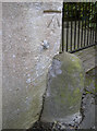
Benchmark, Audley Park Road
A well-defined cutmark on an entrance gate in Audley Park Road - see http://www.bench-marks.org.uk/bm40836 for the Benchmark Database.
Image: © Neil Owen
Taken: 6 Jan 2012
0.13 miles
2
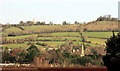
Across the Avon valley
From Shophouse Road, Twerton, with the spire of Locksbrook Cemetery chapel Image https://historicengland.org.uk/listing/the-list/list-entry/1395454 , Primrose Hill wood above, and Beckford's Tower on the skyline.
Image: © Derek Harper
Taken: 9 Dec 2019
0.13 miles
3

Electricity substation in Edward Street
A common sight in Britain's urban landscape, but often overlooked. This one unusually has no fences around it and also has two types of fire hydrant signs on it. Sheltering behind the bush on the right is a benchmark - see Image] for a look.
Image: © Neil Owen
Taken: 6 Jan 2012
0.14 miles
4
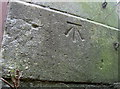
Benchmark on the substation, Edward Street
A nice cutmark, as described in the Benchmark Database: http://www.bench-marks.org.uk/bm40835 , located on the end of an electricity substation in Edward Street. See Image] for a wider view of this common urban utility.
Image: © Neil Owen
Taken: 6 Jan 2012
0.14 miles
5
Eastern corner of Locksbrook Cemetery chapel
The chapel has a double archway and this eastern wing has a benchmark. See Image] for the wider view and Image] for the benchmark.
Image: © Neil Owen
Taken: 6 Jan 2012
0.15 miles
6
Benchmark on the chapel, Locksbrook
A cut benchmark on the east corner of the mortuary chapel in Locksbrook cemetery. For details of it and more nearby see http://www.bench-marks.org.uk/bm40833. For a wider view take a look at http://www.geograph.org.uk/photo/2754119 or Image
Image: © Neil Owen
Taken: 6 Jan 2012
0.15 miles
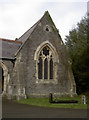
7
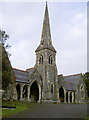
Locksbrook Cemetery chapel
Locksbrook Cemetery is an inner-city oasis of calm despite being a short distance from a major road and the centre of Bath. The chapel is located in the middle of the grounds, and has a benchmark on it - see Image
Image: © Neil Owen
Taken: 6 Jan 2012
0.16 miles
8
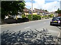
Combe Park
Fine houses with bay windows on Combe Park in Weston in the suburbs of Bath.
Image: © Philip Halling
Taken: 17 May 2021
0.18 miles
9

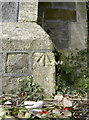
Benchmark on the entrance to a private road
A cutmark on the pillar at the entrance of Park Gardens. The Ordnance Survey lists this mark as a pivot, but it clearly isn't. See http://www.bench-marks.org.uk/bm40837 for the Benchmark Database, and Image] for a wider view.
Image: © Neil Owen
Taken: 6 Jan 2012
0.20 miles
10
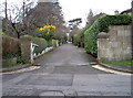
Southern entrance to Park Gardens
This private road has a gate for security and on the right-hand pillar is a benchmark. See Image] for a closer view.
Image: © Neil Owen
Taken: 6 Jan 2012
0.20 miles