IMAGES TAKEN NEAR TO
Midland Road, BATH, BA1 3AX
Introduction
This page details the photographs taken nearby to Midland Road, BA1 3AX by members of the Geograph project.
The Geograph project started in 2005 with the aim of publishing, organising and preserving representative images for every square kilometre of Great Britain, Ireland and the Isle of Man.

There are currently over 7.5m images from over14,400 individuals and you can help contribute to the project by visiting https://www.geograph.org.uk
Image Map
Images are licensed for reuse under creativecommons.org/licenses/by-sa/2.0
Notes
- Clicking on the map will re-center to the selected point.
- The higher the marker number, the further away the image location is from the centre of the postcode.
Image Listing (144 Images Found)
Images are licensed for reuse under creativecommons.org/licenses/by-sa/2.0
Image
Details
Distance
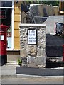
1
Milestone to the Guildhall
Clearly the more important place in Bath. There are a number of similar milestones on the main roads that indicate where the mileage refers to.
Image: © Neil Owen
Taken: 6 Jan 2012
0.02 miles
2
Cast iron milepost
Listed, grade II, with details at: https://www.historicengland.org.uk/listing/the-list/list-entry/1395459
Image: © Michael Dibb
Taken: 2 Jun 2018
0.02 miles
3

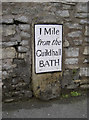
Old Milestone by the A4, Cork Place, Upper Bristol Road, Bath
Metal plate attached to stone post by the A4, in parish of BATH (BATH AND NORTH EAST SOMERSET District), Upper Bristol Road, by No. 8 Cork Place, embedded in stone wall, on North side of road. Bath Guildhall iron plate, erected by the Bath turnpike trust in the 18th century. Re-located safely, and only slightly to the West in 2018 when the large wall was demolished and the site behind was re-developed.
Inscription reads:-
I Mile
from the
Guildhall
BATH
Grade II listed. List Entry Number: 1395459
https://historicengland.org.uk/listing/the-list/list-entry/1395459
Milestone Society National ID: SO_BABR01.
Image: © JR Dowding
Taken: 19 Oct 2003
0.02 miles
4
Another Guildhall milestone
This one is on the Upper Bristol Road. Another milestone in this square: Image
Image: © HelenK
Taken: 16 Jun 2011
0.03 miles
5
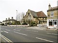
Lower Weston, St. John the Evangelist
Parish church on Upper Bristol Road.
Image: © Mike Faherty
Taken: 8 Mar 2015
0.03 miles
6

Old Milestone by A4, Upper Bristol Road, by No. 8 Cork Place
The Milestone is located embedded in stone wall on the North of the road. Parish of Bath (Bath and North East Somerset District). Metal plate attached to stone post, Bath Guildhall iron plate design, erected by the Bath turnpike trust in the 18th Century, erosion at base. An earlier photograph can be found here: https://www.geograph.org.uk/photo/6038171
Inscription reads:-
I Mile / from the / Guildhall / BATH
Grade II listed. List Entry Number: https://historicengland.org.uk/listing/the-list/list-entry/1395459
Milestone Society National ID: SO_BABR01
Image: © Roadside Relics
Taken: 31 Jan 2023
0.03 miles
7

Parish church
The church of St John is in St Michael's Road.
Image: © Michael Dibb
Taken: 2 Jun 2018
0.03 miles
8

Bath Gas Light and Coke Company
Historical office building for the original gas works.
Image: © don cload
Taken: 12 Sep 2010
0.04 miles
9

Kelso House
Now offices, the building was the headquarters of the Bath Gas Light and Coke Company. Dated 1858, the building reflects the success the company had had. The earliest gasometers on the site were windowless wooden sheds. This site produced gas until 1971 and the works were demolished 1983. Listed, grade II, with details at: https://www.historicengland.org.uk/listing/the-list/list-entry/1395451
Image: © Michael Dibb
Taken: 2 Jun 2018
0.05 miles
10

Bath Gas Light and Coke Company
A piece of Bath history with this building with 'Bath Gas Light and Coke Company' inscribed across the front. Built in the days when there was confidence that there was a permanence. Today in complete contrast businesses and companies come and go so quickly. The building is Grade II listed; see: https://historicengland.org.uk/listing/the-list/list-entry/1395451
Image: © Philip Halling
Taken: 17 May 2021
0.05 miles