IMAGES TAKEN NEAR TO
Upper Bristol Road, BATH, BA1 3AE
Introduction
This page details the photographs taken nearby to Upper Bristol Road, BA1 3AE by members of the Geograph project.
The Geograph project started in 2005 with the aim of publishing, organising and preserving representative images for every square kilometre of Great Britain, Ireland and the Isle of Man.

There are currently over 7.5m images from over14,400 individuals and you can help contribute to the project by visiting https://www.geograph.org.uk
Image Map
Images are licensed for reuse under creativecommons.org/licenses/by-sa/2.0
Notes
- Clicking on the map will re-center to the selected point.
- The higher the marker number, the further away the image location is from the centre of the postcode.
Image Listing (259 Images Found)
Images are licensed for reuse under creativecommons.org/licenses/by-sa/2.0
Image
Details
Distance
1
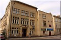
Territorial Army Centre on Upper Bristol Road
Image: © Steve Daniels
Taken: 25 May 2010
0.01 miles
2
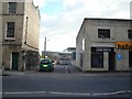
View of Victoria Bridge from Upper Bristol Road
Looking south-southwest down Victoria Bridge Road.
Image: © Robert Lamb
Taken: 15 Apr 2012
0.01 miles
3
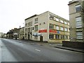
Bath, Army Reserve Centre
On Upper Bristol Road; the building is shared with ACF, Air Cadets and Army Careers Office. http://www.bathchronicle.co.uk/Bath-Army-Reserve-unit-double-size/story-21176096-detail/story.html
Image: © Mike Faherty
Taken: 8 Mar 2015
0.01 miles
5
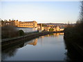
Sunlight on the banks of the Avon
The warm light adds a distinctive glow to the Bath stone of the riverside buildings.
Image: © Neil Owen
Taken: 16 Jan 2012
0.03 miles
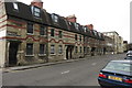
6
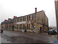
Comfortable Place, Upper Bristol Rd
These are probably among the less comfortable buildings in Bath. The paler pair of houses towards the left, Ivy Lodge (now a B & B) were the headquarters of the North Somerset Yeomanry (A Squadron) in WWI. The drill hall for Wessex Divisional Royal Engineers (HQ & 1 Field Company) and 2nd South Western Mounted Brigade Field Ambulance RAMC (A Section) was nearby: Image
Image: © HelenK
Taken: 6 Oct 2014
0.03 miles
7
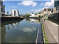
Kennet & Avon Canal Walk
Kennet & Avon Canal Walk by River Avon heading away from Victoria Bridge towards the Destructor Bridge
Image: © Shaun Ferguson
Taken: 5 May 2018
0.03 miles
8
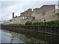
Buildings on the north bank of the Avon, Bath
Just downstream of Victoria Bridge, alongside the Bristol & Bath Railway Path. The nearest building is probably Bath Artists Studios.
Image: © Christine Johnstone
Taken: 3 May 2015
0.04 miles
9
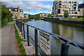
Bath : The River Avon
A sign alongside the Bristol and Bath Railway Path says there has five deaths in five years.
Image: © Lewis Clarke
Taken: 6 Aug 2020
0.04 miles
10
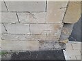
Ordnance Survey Cut Mark
This OS cut mark can be found on No1 Comfortable Place. It marks a point 22.221m above mean sea level.
Image: © Adrian Dust
Taken: 3 Dec 2022
0.04 miles