IMAGES TAKEN NEAR TO
Thoulstone, WESTBURY, BA13 4GF
Introduction
This page details the photographs taken nearby to Thoulstone, BA13 4GF by members of the Geograph project.
The Geograph project started in 2005 with the aim of publishing, organising and preserving representative images for every square kilometre of Great Britain, Ireland and the Isle of Man.

There are currently over 7.5m images from over14,400 individuals and you can help contribute to the project by visiting https://www.geograph.org.uk
Image Map (Loading...)


Getting Data...Please wait
Leaflet Map data © OpenStreetMap
Images are licensed for reuse under creativecommons.org/licenses/by-sa/2.0
Notes
- Clicking on the map will re-center to the selected point.
- The higher the marker number, the further away the image location is from the centre of the postcode.
Image Listing (11 Images Found)
Images are licensed for reuse under creativecommons.org/licenses/by-sa/2.0
Image
Details
Distance

2
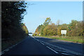
A36 at Dead Maids Junction
A junction with the A3098. These days the crossing is grade separated, the A3098 passing over the bridge ahead, and with widely separated connecting slip roads. The slip for the northbound A36 is just behind the viewpoint, and uses the old road alignment, meeting the A3098 at the original Dead Maids Crossroads. A late 17th century farmhouse called Summerstead is there, it was originally called Dead Maids. It is not clear whether the crossroads or the farm were so named first. The most popular story accounting for the name involves three deaths, but two were men, only one maid, so that seems unsatisfactory.
Image: © Robin Webster
Taken: 13 Nov 2022
0.12 miles
3
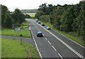
2008 : Junction on the A36
As a complete contrast to Image] we now see the A36 on its way to Warminster and Salisbury. The junction below leads up to the A3098.
Take this road, turn right on the A3098 and take the first left. You could call it the approach to the approach to the approach to Short Street.
Image: © Maurice Pullin
Taken: 1 Sep 2008
0.18 miles
4
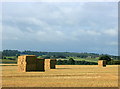
2008 : Former wheatfield near Chapmanslade
At the end of an anxious month for the farmer the wheat, at least, has been safely gathered in. Now to find something else to worry about.
Image: © Maurice Pullin
Taken: 1 Sep 2008
0.18 miles
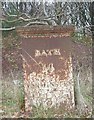
5

Old Milestone by the A36, Bath Road, Chapmanslade parish
Stone post (plate lost) by the A36, in parish of CHAPMANSLADE (WEST WILTSHIRE District), Bath Road; Chapmanslade, between flyover and A3098 sliproad on verge to left of WI_BAWM14 Image, on Northeast side of road. Erected by the Black Dog turnpike trust in the 18th century.
Inscription reads:-
To
Bath 14 Mil(es)
Warminſter
3
(1)766
Rivet on top, benchmark not visible.
Milestone Society National ID: WI_BAWM14a
Image: © M Faherty
Taken: 15 Dec 2007
0.21 miles
6
Old Milestone by the A36, Bath Road, Chapmanslade parish
Metal plate attached to stone post by the A36, in parish of CHAPMANSLADE (WEST WILTSHIRE District), Bath Road, Chapmanslade, between flyover and A3098 slip road on verge to right of WI_BAWM14a Image, on North side of road. C&M Classical iron casting, erected by the Black Dog turnpike trust in the 19th century.
Inscription reads:-
BATH
14
WARMINSTER
3
(parish name not visible)
Grade II listed.
List Entry Number: 1193904 https://historicengland.org.uk/listing/the-list/list-entry/1193904
Milestone Society National ID: WI_BAWM14.
Image: © M Faherty
Taken: 15 Dec 2007
0.21 miles
7
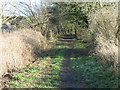
The Drove
A view looking east along The Drove, a track leading off Thoulstone Lane.
Image: © Phil Williams
Taken: 17 Dec 2006
0.24 miles
8
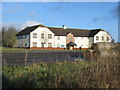
Clubhouse at Thoulstone Park
A view looking north to the boarded up clubhouse at the former Thoulstone Park Golf Course.
Image: © Phil Williams
Taken: 17 Dec 2006
0.24 miles
9
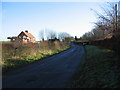
Thoulstone Cottages
A view looking to the southeast along Thoulstone Lane towards Thoulstone Cottages. This lane used to form part of the A36 trunk road.
Image: © Phil Williams
Taken: 17 Dec 2006
0.24 miles
10
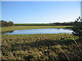
Flooded field at Thoulstone
A view looking to the southeast across flooded farmland, towards Thoulstone Cottages.
Image: © Phil Williams
Taken: 17 Dec 2006
0.24 miles