IMAGES TAKEN NEAR TO
Monmouth Place, BATH, BA1 2NP
Introduction
This page details the photographs taken nearby to Monmouth Place, BA1 2NP by members of the Geograph project.
The Geograph project started in 2005 with the aim of publishing, organising and preserving representative images for every square kilometre of Great Britain, Ireland and the Isle of Man.

There are currently over 7.5m images from over14,400 individuals and you can help contribute to the project by visiting https://www.geograph.org.uk
Image Map
Images are licensed for reuse under creativecommons.org/licenses/by-sa/2.0
Notes
- Clicking on the map will re-center to the selected point.
- The higher the marker number, the further away the image location is from the centre of the postcode.
Image Listing (759 Images Found)
Images are licensed for reuse under creativecommons.org/licenses/by-sa/2.0
Image
Details
Distance
1
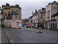
Road junction - Charlotte Street and Monmouth Street
Image: © Rob Purvis
Taken: 2 Feb 2010
0.02 miles
2

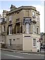
Ghost sign, Monmouth Place, Bath
A defunct cafe advertising its hardly earth-shattering wares, teas and snacks.
Image: © Stephen Richards
Taken: 25 May 2012
0.03 miles
3
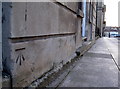
Benchmark opposite Charlotte Street car park
View of a cut mark as listed in the Database http://www.bench-marks.org.uk/bm37611.
Image: © Neil Owen
Taken: 8 Apr 2011
0.03 miles
4
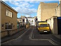
View up Cumberland Row from New King Street
Looking north-northeast.
Image: © Robert Lamb
Taken: 15 Apr 2012
0.03 miles
5
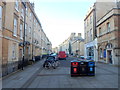
New King Street, Bath
A view WNW from the Charles Street end. A Christadelphian Hall http://www.geograph.org.uk/photo/2090542 is on the right.
Image: © Jaggery
Taken: 10 Dec 2012
0.03 miles
6
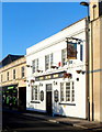
The New Inn, Bath
Pub at 23-24 Monmouth Place.
Image: © Jaggery
Taken: 10 Dec 2012
0.03 miles
7
Either way will do
An old wall sign, seemingly maintained, on the junction of the Upper Bristol Road and Charlotte Street. The garage is no longer there, though.
Following another visit on a sunny day a strange but faint sign could be discerned in the stonepaint at ground level. See Image] for a look at the ghostly image.
Image: © Neil Owen
Taken: 8 Mar 2012
0.03 miles
8

History emerging from the paintwork
Catch the place at the right time in the afternoon on a sunny day and this faint legend can be made out. It has the words: Western Counties Automobile Co. Ltd. Bath See Image] for a view of the modern painted signs.
Image: © Neil Owen
Taken: 24 May 2012
0.03 miles
9
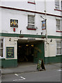
King's Arms
As befits a seventeenth century coaching inn there is a fine pair of doors, capable of allowing horse-drawn traffic.
Image: © Neil Owen
Taken: 8 Mar 2012
0.03 miles
10
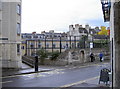
Junction of Monmouth Place and Cumberland Row
The former school buildings were damaged in the war, but have been the home of Percy community centre since 1991. A benchmark remains on the corner nearest the bus stop, and is listed in the 1st Geodetic Levelling of the late 1800's.
Close-up: Image]
Image: © Neil Owen
Taken: 30 Sep 2010
0.03 miles