IMAGES TAKEN NEAR TO
Cumberland Row, BATH, BA1 2AS
Introduction
This page details the photographs taken nearby to Cumberland Row, BA1 2AS by members of the Geograph project.
The Geograph project started in 2005 with the aim of publishing, organising and preserving representative images for every square kilometre of Great Britain, Ireland and the Isle of Man.

There are currently over 7.5m images from over14,400 individuals and you can help contribute to the project by visiting https://www.geograph.org.uk
Image Map (Loading...)


Getting Data...Please wait
Leaflet Map data © OpenStreetMap
Images are licensed for reuse under creativecommons.org/licenses/by-sa/2.0
Notes
- Clicking on the map will re-center to the selected point.
- The higher the marker number, the further away the image location is from the centre of the postcode.
Image Listing (849 Images Found)
Images are licensed for reuse under creativecommons.org/licenses/by-sa/2.0
Image
Details
Distance
1
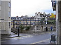
Junction of Monmouth Place and Cumberland Row
The former school buildings were damaged in the war, but have been the home of Percy community centre since 1991. A benchmark remains on the corner nearest the bus stop, and is listed in the 1st Geodetic Levelling of the late 1800's.
Close-up: Image]
Image: © Neil Owen
Taken: 30 Sep 2010
0.01 miles
2
Benchmark on wall at junction of Monmouth Place and Cumberland Row
Ordnance Survey cut mark benchmark described on the Bench Mark Database at http://www.bench-marks.org.uk/bm37095
Image: © Roger Templeman
Taken: 19 Feb 2011
0.01 miles
3
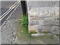
Ordnance Survey Cut Mark
This OS cut mark can be found on the wall SW side of Monmouth Place. It marks a point 23.932m above mean sea level.
Image: © Adrian Dust
Taken: 3 Dec 2022
0.01 miles
4
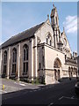
St Paul's Church, St Paul's Place
At the junction with Palace Yard Mews. Taken from Monmouth Place
Image: © Robin Sones
Taken: 8 Sep 2014
0.01 miles
5
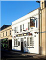
The New Inn, Bath
Pub at 23-24 Monmouth Place.
Image: © Jaggery
Taken: 10 Dec 2012
0.01 miles
6
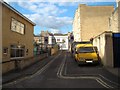
View up Cumberland Row from New King Street
Looking north-northeast.
Image: © Robert Lamb
Taken: 15 Apr 2012
0.01 miles
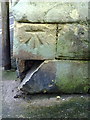
7
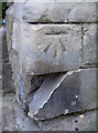
Cut benchmark
Close-up of the mark made in the old school walls and mentioned in the first survey (1GL). See here Image] for a wide view.
See these for more information on benchmarks and surveying:
http://www.deformedweb.co.uk/trigs/1gl.cgi
http://www.bench-marks.org.uk/
Image: © Neil Owen
Taken: 30 Sep 2010
0.01 miles
8
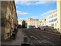
View up Charles Street from New King Street
Looking north-northeast.
Image: © Robert Lamb
Taken: 15 Apr 2012
0.02 miles
9
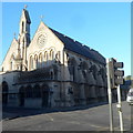
Former Holy Trinity Church, Bath
The former Church of England church is on the corner of Chapel Row and St Paul's Place. It was closed down by its parochial church council in February 2011 because of the £40,000 cost of the repairs that would have been needed to update its electrical system.
Image: © Jaggery
Taken: 10 Dec 2012
0.02 miles
10
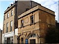
Christadelphian Hall, Bath
On New King Street, and occupying premises dated 1880. Number 55 on the left dates from about 1770, and the pair originally formed "a symmetrical composition ..., the blind former centre bay surviving" http://www.imagesofengland.org.uk/Details/Default.aspx?id=446740&mode=adv . But one of the main reasons for taking the photo was the remnants of the advertising on the right-hand wall.
Image: © Derek Harper
Taken: 3 Jun 2005
0.03 miles