IMAGES TAKEN NEAR TO
Plants Green, WARMINSTER, BA12 9NW
Introduction
This page details the photographs taken nearby to Plants Green, BA12 9NW by members of the Geograph project.
The Geograph project started in 2005 with the aim of publishing, organising and preserving representative images for every square kilometre of Great Britain, Ireland and the Isle of Man.

There are currently over 7.5m images from over14,400 individuals and you can help contribute to the project by visiting https://www.geograph.org.uk
Image Map
Images are licensed for reuse under creativecommons.org/licenses/by-sa/2.0
Notes
- Clicking on the map will re-center to the selected point.
- The higher the marker number, the further away the image location is from the centre of the postcode.
Image Listing (89 Images Found)
Images are licensed for reuse under creativecommons.org/licenses/by-sa/2.0
Image
Details
Distance
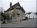
1

Warminster - Eastway House
Located in East Street this house was the home of Doctor Edwin Sloper Beaven, an internationally famous maltster and barley breeder. His work increased the production of barley yields by 20%.
Image: © Chris Talbot
Taken: 31 Jan 2009
0.08 miles
2
Warminster - East Street
This house is on the junction of East Street and Imber Road.
Image: © Chris Talbot
Taken: 31 Jan 2009
0.08 miles
3
Warminster - Morley Cottage
This bungalow has the look of a roman temple about it.
Image: © Chris Talbot
Taken: 31 Jan 2009
0.08 miles
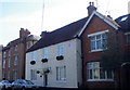
4

Warminster - The Rose And Crown
This small public house is in East Street.
Image: © Chris Talbot
Taken: 31 Jan 2009
0.08 miles
5
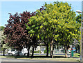
2010 : A laburnum, a copper beech and a hawthorn
Next to the B3414 Boreham Road, Warminster.
Not to mention the lamp standard.
Image: © Maurice Pullin
Taken: 22 May 2010
0.09 miles
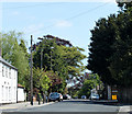
6
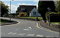
Northern end of Plants Green, Warminster
Viewed across the B3414 East Street.
Image: © Jaggery
Taken: 9 May 2014
0.09 miles
7
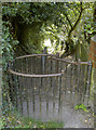
A kiss for luck
No taking the bike or pram down this path - unless you can carry it head-high.
Image: © Neil Owen
Taken: 2 May 2013
0.10 miles
8
2010 : B3414 Boreham Road, Warminster
Heading east out of Warminster toward Boreham, Norton Bavant and Heytesbury.
Image: © Maurice Pullin
Taken: 22 May 2010
0.10 miles
9
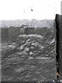
Bench Mark, 22 Boreham Road
The bench mark is on the north east side of the building. For a view of the building Image and for more information on the bench mark and others in the area http://www.bench-marks.org.uk/bm37305
Image: © Maigheach-gheal
Taken: 14 Mar 2011
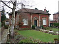
0.10 miles
10
The Old Manse, Warminster
The house dates from the late 18th century and it is built of coursed rubble which has been painted. There is an Ordnance Survey bench mark on the north east angle.
Image: © Maigheach-gheal
Taken: 14 Mar 2011
0.10 miles