IMAGES TAKEN NEAR TO
Weymouth Street, WARMINSTER, BA12 9NR
Introduction
This page details the photographs taken nearby to Weymouth Street, BA12 9NR by members of the Geograph project.
The Geograph project started in 2005 with the aim of publishing, organising and preserving representative images for every square kilometre of Great Britain, Ireland and the Isle of Man.

There are currently over 7.5m images from over14,400 individuals and you can help contribute to the project by visiting https://www.geograph.org.uk
Image Map
Images are licensed for reuse under creativecommons.org/licenses/by-sa/2.0
Notes
- Clicking on the map will re-center to the selected point.
- The higher the marker number, the further away the image location is from the centre of the postcode.
Image Listing (356 Images Found)
Images are licensed for reuse under creativecommons.org/licenses/by-sa/2.0
Image
Details
Distance
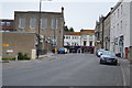
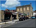
2

Fading from the past
The old Kings Arms in Weymouth Street retains little of the original signage. See Image] for a wider view.
Image: © Neil Owen
Taken: 7 Oct 2014
0.01 miles
3
Night times only
The old Kings Arms pub was opened in the 1830s and continued to serve customers until quite recently. It is listed Grade II but now it is a nightclub called John Barleycorn. See Image] for a vestige of the old pub.
Image: © Neil Owen
Taken: 7 Oct 2014
0.01 miles
4

No. 13 Weymouth Road, Warminster
The building dates from circa 1830 and is in the Tudor Gothic style. Used by J&K Animal Feeds. There is an Ordnance Survey bench mark on the north west face of the building.
Image: © Maigheach-gheal
Taken: 5 Sep 2010
0.01 miles
5
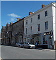
KS Bar and Coffee Shop, Warminster
KS on the right is at 9 Weymouth Street. Also in view are A Touch of Tradition ( traditional and designer materials for interior house decoration) and Raves from the Grave (CDs, DVDs, videos, vinyl etc).
Image: © Jaggery
Taken: 9 May 2014
0.02 miles
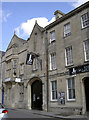
6

John Barleycorn
Grade II listed. http://www.britishlistedbuildings.co.uk/en-313047-the-king-s-arms-warminster-
Image: © N Chadwick
Taken: 10 Jun 2016
0.02 miles
7

Bench Mark, Old Town Hall, Warminster
The bench mark is to be found to the right of the door. For a wider view of the building http://www.geograph.org.uk/photo/2053266 and for further information regarding the bench mark http://www.bench-marks.org.uk/bm35447
A bench mark is an Ordnance Survey arrowhead sign found on walls, bridges, churches and specially erected triangulation pillars where the altitude above sea-level has been accurately measured by surveyors. The arrowhead points to a horizontal line above it which marks the exact altitude.
With rivets and pivots there is no datum (horizontal line) cut, the pointed-to horizontal surface defining the datum height.
Image: © Maigheach-gheal
Taken: 5 Sep 2010
0.02 miles
8
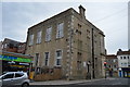
Warminster Town Hall
Grade II listed. http://www.britishlistedbuildings.co.uk/en-312952-town-hall-warminster-
Image: © N Chadwick
Taken: 10 Jun 2016
0.02 miles
9

Warminster Town Hall
Grade II listed. http://www.britishlistedbuildings.co.uk/en-312952-town-hall-warminster-
Image: © N Chadwick
Taken: 10 Jun 2016
0.02 miles
10
Weymouth Street shops, Warminster
The short row of single-storey buildings is on the west side of Weymouth Street.
The two-storey building behind the row is on the corner of the B3414 Market Place.
Image: © Jaggery
Taken: 9 May 2014
0.02 miles