IMAGES TAKEN NEAR TO
Weymouth Street, WARMINSTER, BA12 9NP
Introduction
This page details the photographs taken nearby to Weymouth Street, BA12 9NP by members of the Geograph project.
The Geograph project started in 2005 with the aim of publishing, organising and preserving representative images for every square kilometre of Great Britain, Ireland and the Isle of Man.

There are currently over 7.5m images from over14,400 individuals and you can help contribute to the project by visiting https://www.geograph.org.uk
Image Map
Images are licensed for reuse under creativecommons.org/licenses/by-sa/2.0
Notes
- Clicking on the map will re-center to the selected point.
- The higher the marker number, the further away the image location is from the centre of the postcode.
Image Listing (353 Images Found)
Images are licensed for reuse under creativecommons.org/licenses/by-sa/2.0
Image
Details
Distance
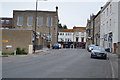
1
Back of the Old Warehouse, Warminster
Premises of J&K Burton Animal Feeds. http://www.geograph.org.uk/photo/3970367 to a front view.
Image: © Jaggery
Taken: 9 May 2014
0.00 miles
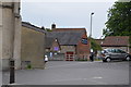
2
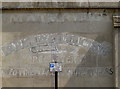
J&K Burton Animal Feeds, Warminster
Located in The Old Warehouse, 13 Weymouth Street. I spent part of my lunch break on a bench opposite, trying to decipher the ghost writing on the wall. I concluded that there were parts of at least two layers of text visible, resulting in a mostly meaningless mishmash. Fragments that were meaningful were of no use - WARM was obviously part of WARMINSTER (this town), WEY was part of WEYMOUTH (this street) and MERCHANT.
Image: © Jaggery
Taken: 9 May 2014
0.00 miles
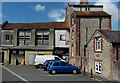
3
Years of trading
The current premises of J&K Burton's animal supplies has had a much longer history as the faded signs show. Except the parking restrictions, obviously.
Image: © Neil Owen
Taken: 2 May 2013
0.01 miles
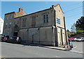
4

No. 13 Weymouth Road, Warminster
The building dates from circa 1830 and is in the Tudor Gothic style. Used by J&K Animal Feeds. There is an Ordnance Survey bench mark on the north west face of the building.
Image: © Maigheach-gheal
Taken: 5 Sep 2010
0.01 miles
5
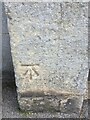
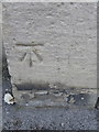
OS Cut Mark - Warminster, Number 13 Weymouth Road
https://www.bench-marks.org.uk/bm35446
Image: © thejackrustles
Taken: 23 Jun 2021
0.01 miles
6
Bench Mark, Weymouth Road
The bench mark is to be found on the north west angle of the building. For a view of the building http://www.geograph.org.uk/photo/2053004 and for further information on the cut mark http://www.bench-marks.org.uk/bm35446
A bench mark is an Ordnance Survey arrowhead sign found on walls, bridges, churches and specially erected triangulation pillars where the altitude above sea-level has been accurately measured by surveyors. The arrowhead points to a horizontal line above it which marks the exact altitude.
With rivets and pivots there is no datum (horizontal line) cut, the pointed-to horizontal surface defining the datum height.
Image: © Maigheach-gheal
Taken: 5 Sep 2010
0.01 miles
8

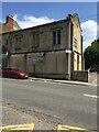
Warminster - Former Town Hall
This grand building stands unused apart from the pigeons.
Image: © Chris Talbot
Taken: 31 Jan 2009
0.02 miles