IMAGES TAKEN NEAR TO
Flers Court, WARMINSTER, BA12 9NJ
Introduction
This page details the photographs taken nearby to Flers Court, BA12 9NJ by members of the Geograph project.
The Geograph project started in 2005 with the aim of publishing, organising and preserving representative images for every square kilometre of Great Britain, Ireland and the Isle of Man.

There are currently over 7.5m images from over14,400 individuals and you can help contribute to the project by visiting https://www.geograph.org.uk
Image Map
Images are licensed for reuse under creativecommons.org/licenses/by-sa/2.0
Notes
- Clicking on the map will re-center to the selected point.
- The higher the marker number, the further away the image location is from the centre of the postcode.
Image Listing (380 Images Found)
Images are licensed for reuse under creativecommons.org/licenses/by-sa/2.0
Image
Details
Distance
1
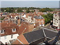
Warminster town centre
The Athenaeum on the right of the photo is on High Street, the road in the centre of the photo is George Street running to the west.
Image: © David Hawgood
Taken: 10 Sep 2006
0.02 miles
2
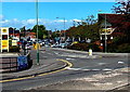
Entrance road to Morrisons, Warminster
From Weymouth Street. The fuel prices on display on the left on May 9th 2014 are 128.9 pence
per litre for unleaded petrol and 133.9 pence per litre for diesel. After an unexpected but sustained drop in prices in late 2014 and into 2015, prices at the mid-January 2015 date of this upload
are at least 20 pence lower in many parts of the UK.
Image: © Jaggery
Taken: 9 May 2014
0.04 miles
3
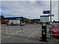
Morrisons Warminster
The view of the supermarket in Warminster.
Image: © Gordon Griffiths
Taken: 9 Oct 2022
0.05 miles
4
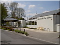
Warminster Civic Centre
The centre was refurbished in late 2011 and has a number of facilities and rooms for hire. It even shows films on a monthly basis.
Today was local election day.
Image: © Neil Owen
Taken: 2 May 2013
0.05 miles
5
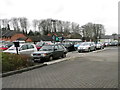
Car park, Warminster
The car park of Morrisons supermarket.
Image: © Maigheach-gheal
Taken: 14 Jan 2012
0.05 miles
6
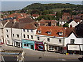
Shops in High Street, Warminster
From the tower of the Chapel of St Lawrence
Image: © David Hawgood
Taken: 10 Sep 2006
0.05 miles
7
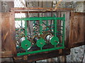
Faceless clock, St Lawrence Chapel, Warminster
This clock purchased in 1765 strikes the hour and quarters, but has no face or hands. There has been a clock in the tower of the chapel since the mid seventeenth century. The bell struck on the hour was cast in 1657. It was also the curfew bell, sounded at 7pm or 8pm to tell the townspeople to cover their fires - "curfew" - to avoid the risk of fire in a town with wooden houses. It was also struck at 4am as a rising bell.
Image: © David Hawgood
Taken: 10 Sep 2006
0.05 miles
8

Sexton's cottage, St Lawrence Chapel, Warminster
The sexton rang the curfew bell at 7pm or 8pm, and the rising bell at 4am.
See Image for more information on curfew. He could ring the bell in the tower using a rope that ran down into his cottage; the photo shows its sloping tube from the cottage to the chapel.
Image: © David Hawgood
Taken: 10 Sep 2006
0.05 miles
9
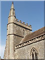
Chapel of St Lawrence, Warminster
14th Century tower; the rest of the building is 19th Century. The chapel is a foundation independent of the Church of England, though the vicar of the parish church St Denys acts as priest. It has been held in trust since 1575 by feoffees for the use of the townspeople. See also Image and Image
Image: © David Hawgood
Taken: 10 Sep 2006
0.05 miles
10
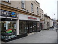
Warminster - Woolworths
The now defunct Woolworths shop in the High Street.
Image: © Chris Talbot
Taken: 31 Jan 2009
0.05 miles