IMAGES TAKEN NEAR TO
Prestbury Drive, WARMINSTER, BA12 9LQ
Introduction
This page details the photographs taken nearby to Prestbury Drive, BA12 9LQ by members of the Geograph project.
The Geograph project started in 2005 with the aim of publishing, organising and preserving representative images for every square kilometre of Great Britain, Ireland and the Isle of Man.

There are currently over 7.5m images from over14,400 individuals and you can help contribute to the project by visiting https://www.geograph.org.uk
Image Map
Images are licensed for reuse under creativecommons.org/licenses/by-sa/2.0
Notes
- Clicking on the map will re-center to the selected point.
- The higher the marker number, the further away the image location is from the centre of the postcode.
Image Listing (26 Images Found)
Images are licensed for reuse under creativecommons.org/licenses/by-sa/2.0
Image
Details
Distance
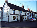
1

Milepost, Warminster
On the B3413 entering Warminster.
Image: © Maigheach-gheal
Taken: 16 Mar 2009
0.12 miles

3
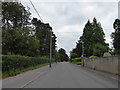
Looking east-southeast along Boreham Road
Image: © Basher Eyre
Taken: 22 Aug 2016
0.15 miles
4
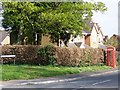
Telephone box, Highbury Park
K6 style telephone box on a residential street off the B3414.
Image: © Maigheach-gheal
Taken: 19 Apr 2009
0.16 miles
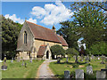
6

Boreham, parish church
The parish church of Bishopstow and Boreham, on Boreham Road.
Image: © Mike Faherty
Taken: 28 Feb 2017
0.20 miles
7

St John the Evangelist, Boreham: churchyard (a)
Image: © Basher Eyre
Taken: 22 Aug 2016
0.20 miles
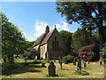
10

St John the Evangelist, Boreham: churchyard (h)
Image: © Basher Eyre
Taken: 22 Aug 2016
0.20 miles