IMAGES TAKEN NEAR TO
Willow Crescent, WARMINSTER, BA12 9LH
Introduction
This page details the photographs taken nearby to Willow Crescent, BA12 9LH by members of the Geograph project.
The Geograph project started in 2005 with the aim of publishing, organising and preserving representative images for every square kilometre of Great Britain, Ireland and the Isle of Man.

There are currently over 7.5m images from over14,400 individuals and you can help contribute to the project by visiting https://www.geograph.org.uk
Image Map
Images are licensed for reuse under creativecommons.org/licenses/by-sa/2.0
Notes
- Clicking on the map will re-center to the selected point.
- The higher the marker number, the further away the image location is from the centre of the postcode.
Image Listing (18 Images Found)
Images are licensed for reuse under creativecommons.org/licenses/by-sa/2.0
Image
Details
Distance
1
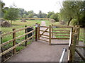
Entrance to Smallbrook
A nice new wooden gate to greet visitors to this important water meadow conservation area.
Image: © Neil Owen
Taken: 27 Sep 2013
0.08 miles
2
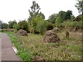
Smallbrook reserve
The nature conservation area, taking the Wylye River's meanderings and some of the lush water meadows as it runs towards Salisbury. With a bit of luck you might catch a glimpse of an otter, a water vole or even Daubenton's bats.
Image: © Neil Owen
Taken: 27 Sep 2013
0.08 miles
3
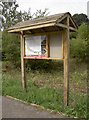
Welcome to Smallbrook Meadows
An information board for the Smallbrook Meadows Nature Reserve.
Image: © Neil Owen
Taken: 27 Sep 2013
0.12 miles
4
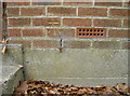
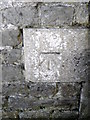
Benchmark where the waters flow
A cutmark, as listed in the Benchmark Database: http://www.bench-marks.org.uk/bm52858 , on a small sewage pumping station. See Image] for a wider view.
Image: © Neil Owen
Taken: 27 Sep 2013
0.13 miles
5
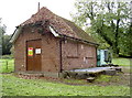
Pumping station
The small unit along Smallbrook Road pumps sewage out of Warminster - but you'd realise that before getting too close. See Image] for a benchmark.
Image: © Neil Owen
Taken: 27 Sep 2013
0.13 miles
6
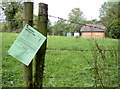
Stop by and have a read
Planning notice hanging on a post along Smallbrook Road - not a terribly busy road it has to be said. The application is for a new vehicular access and hardstanding nearby.
Image: © Neil Owen
Taken: 27 Sep 2013
0.14 miles
7
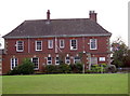
Warminster Conservative Club
A grand venue for the town's good and great to gather.
Image: © Neil Owen
Taken: 27 Sep 2013
0.20 miles
8
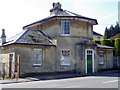
Holly Lodge, Boreham Road
The toll house was built by the Warminster Turnpike Trust in 1840 and is built of ashlar.
Image: © Maigheach-gheal
Taken: 14 Mar 2011
0.22 miles
9
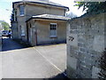
Holly Lodge, Boreham Road
The toll house was built by the Warminster Turnpike Trust in 1840. There is an Ordnance Survey bench mark on the wall on the right hand side of the image.
Image: © Maigheach-gheal
Taken: 14 Mar 2011
0.22 miles
10
Bench Mark, 70 Boreham Road, Warminster
The bench mark is on the north east corner of the wall. For a view of the wall Image and for further information on the bench mark and others in the area http://www.bench-marks.org.uk/bm37294
Image: © Maigheach-gheal
Taken: 14 Mar 2011
0.22 miles