IMAGES TAKEN NEAR TO
Bishopstrow, WARMINSTER, BA12 9HH
Introduction
This page details the photographs taken nearby to BA12 9HH by members of the Geograph project.
The Geograph project started in 2005 with the aim of publishing, organising and preserving representative images for every square kilometre of Great Britain, Ireland and the Isle of Man.

There are currently over 7.5m images from over14,400 individuals and you can help contribute to the project by visiting https://www.geograph.org.uk
Image Map
Images are licensed for reuse under creativecommons.org/licenses/by-sa/2.0
Notes
- Clicking on the map will re-center to the selected point.
- The higher the marker number, the further away the image location is from the centre of the postcode.
Image Listing (10 Images Found)
Images are licensed for reuse under creativecommons.org/licenses/by-sa/2.0
Image
Details
Distance
1
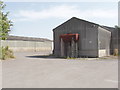
Farm buildings, Bishopstrow, near Warminster
View from public bridleway which leads onto the military training area.
Image: © David Hawgood
Taken: 10 Sep 2006
0.08 miles
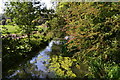
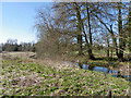
2
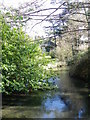
River Wylye, Boreham
The Wylye is generally regarded as the most notable of the Avon tributaries.
Looking downstream.
Image: © Maigheach-gheal
Taken: 14 Mar 2011
0.10 miles
3
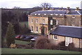
Bishopstrow House
The present Bishopstrow House was built in 1817 to a design by John Pinch and was owned by the Temple family until well into the 20th century. It was turned into a luxury hotel in 1977.
Image: © Stephen McKay
Taken: Unknown
0.10 miles
4
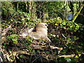
Dead deer, Boreham
Beside the footpath to Bishopstrow Church is a dead Roe deer buck.
Image: © Maigheach-gheal
Taken: 14 Mar 2011
0.11 miles
5
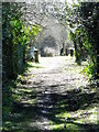
Footpath, Boreham
The footpath takes walkers from the B3414 to Bishopstrow Church.
Image: © Maigheach-gheal
Taken: 14 Mar 2011
0.12 miles
6

Bench Mark, Old Stones, Boreham
The bench mark is on the south east angle of the house in Image and for further information on the bench mark and others in the area http://www.bench-marks.org.uk/bm37293
Image: © Maigheach-gheal
Taken: 14 Mar 2011
0.12 miles
7
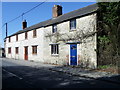
Cottages, Boreham
A row of cottages beside the B3414 in Boreham. There is an Ordnance Survey bench mark on the nearest angle to the camera.
Image: © Maigheach-gheal
Taken: 14 Mar 2011
0.12 miles
8
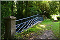
Bridge over the River Wylyle near Bishopstrow
The left hand parapet is this rather fine blue metal one while that to the right (perhaps a replacement?) is plain brickwork.
Image: © David Martin
Taken: 3 Sep 2018
0.12 miles
10
River Wylye, Boreham
The River Wylye contains an excellent stock of mostly wild Brown Trout and Grayling although this is supplemented by some stocking of Brown Trout.
Image: © Maigheach-gheal
Taken: 14 Mar 2011
0.16 miles