IMAGES TAKEN NEAR TO
Boreham Road, WARMINSTER, BA12 9HF
Introduction
This page details the photographs taken nearby to Boreham Road, BA12 9HF by members of the Geograph project.
The Geograph project started in 2005 with the aim of publishing, organising and preserving representative images for every square kilometre of Great Britain, Ireland and the Isle of Man.

There are currently over 7.5m images from over14,400 individuals and you can help contribute to the project by visiting https://www.geograph.org.uk
Image Map
Images are licensed for reuse under creativecommons.org/licenses/by-sa/2.0
Notes
- Clicking on the map will re-center to the selected point.
- The higher the marker number, the further away the image location is from the centre of the postcode.
Image Listing (16 Images Found)
Images are licensed for reuse under creativecommons.org/licenses/by-sa/2.0
Image
Details
Distance
1
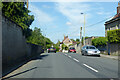
B3414 Boreham Road
Towards the centre of Warminster. The old route of the A36 before a bypass was built.
Image: © Robin Webster
Taken: 30 May 2021
0.05 miles
2
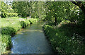
2010 : River Wylye, between Bishopstrow and Boreham
East of Warminster, looking downstream toward Norton Bavant.
Image: © Maurice Pullin
Taken: 22 May 2010
0.11 miles
4
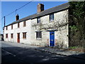
Cottages, Boreham
A row of cottages beside the B3414 in Boreham. There is an Ordnance Survey bench mark on the nearest angle to the camera.
Image: © Maigheach-gheal
Taken: 14 Mar 2011
0.15 miles
5

Bench Mark, Old Stones, Boreham
The bench mark is on the south east angle of the house in Image and for further information on the bench mark and others in the area http://www.bench-marks.org.uk/bm37293
Image: © Maigheach-gheal
Taken: 14 Mar 2011
0.16 miles
6
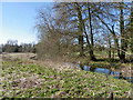
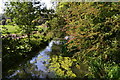
River Wylye, Boreham
The River Wylye contains an excellent stock of mostly wild Brown Trout and Grayling although this is supplemented by some stocking of Brown Trout.
Image: © Maigheach-gheal
Taken: 14 Mar 2011
0.16 miles
7
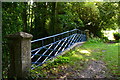
Bridge over the River Wylyle near Bishopstrow
The left hand parapet is this rather fine blue metal one while that to the right (perhaps a replacement?) is plain brickwork.
Image: © David Martin
Taken: 3 Sep 2018
0.16 miles
8
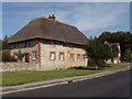
Thatched house in Boreham, Warminster
On west side of Woodcock Road, near junction with Boreham Road.
Image: © David Hawgood
Taken: 10 Sep 2006
0.16 miles
9
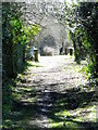
Footpath, Boreham
The footpath takes walkers from the B3414 to Bishopstrow Church.
Image: © Maigheach-gheal
Taken: 14 Mar 2011
0.16 miles
10

2010 : Woodcock Road, Warminster
At the junction with Heronslade, seen left, mostly residential at this end.
Joins the B3414 about 200 yards on.
Image: © Maurice Pullin
Taken: 22 May 2010
0.17 miles