IMAGES TAKEN NEAR TO
Station Road, WARMINSTER, BA12 9FF
Introduction
This page details the photographs taken nearby to Station Road, BA12 9FF by members of the Geograph project.
The Geograph project started in 2005 with the aim of publishing, organising and preserving representative images for every square kilometre of Great Britain, Ireland and the Isle of Man.

There are currently over 7.5m images from over14,400 individuals and you can help contribute to the project by visiting https://www.geograph.org.uk
Image Map
Images are licensed for reuse under creativecommons.org/licenses/by-sa/2.0
Notes
- Clicking on the map will re-center to the selected point.
- The higher the marker number, the further away the image location is from the centre of the postcode.
Image Listing (295 Images Found)
Images are licensed for reuse under creativecommons.org/licenses/by-sa/2.0
Image
Details
Distance
1
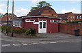
British Red Cross hall, Warminster
Viewed across Station Road.
Image: © Jaggery
Taken: 9 May 2014
0.03 miles
2
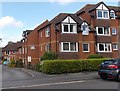
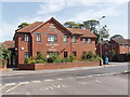
Homeminster House, Warminster
Viewed across Station Road less than 100 metres from the main entrance to Warminster railway station. Homeminster House, built in 1986, is retirement/sheltered housing.
There are 80 flats, resident management staff and community alarm service.
Image: © Jaggery
Taken: 9 May 2014
0.03 miles
3
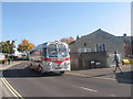
Road to the Car Park
The road leading to a car park in Warminster town centre. Silver Star Leyland Tiger Cub MMR552 is visiting on a vintage bus running day.
Image: © David Roberts
Taken: 12 Oct 2008
0.03 miles
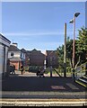
5
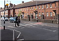
Zebra crossing, Station Road, Warminster
Although Belisha beacons had marked pedestrian crossings in the UK from 1934, it was not until 1951 that the now familiar black and white stripes stretching across the width of the road were officially introduced. Previously, there were only metal studs across the road surface.
Image: © Jaggery
Taken: 9 May 2014
0.05 miles
6
Surgery and pharmacy, Warminster
"The Avenue Doctor's Surgery and Pharmacy" is just north of the town centre car parks by the cornmarket and library.
Image: © David Hawgood
Taken: 10 Sep 2006
0.05 miles
7
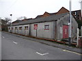
Warminster - Former Scout Hut
This former scout hut is near the railway station.
Image: © Chris Talbot
Taken: 31 Jan 2009
0.05 miles
8

Warminster - Former Scout Hut
This peeling sign is on the former scout hut near the railway station.
Image: © Chris Talbot
Taken: 31 Jan 2009
0.05 miles
9
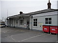
Warminster - Railway Station
This station was built for the Wiltshire Somerset and Weymouth Railway in 1851.
Image: © Chris Talbot
Taken: 31 Jan 2009
0.05 miles
10
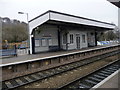
Warminster - Railway Station
Looking towards platform two from platform one.
Image: © Chris Talbot
Taken: 31 Jan 2009
0.05 miles